You are here: Home > Network List > 5H - Central Virginia and South Carolina seismic monitoring experiment Stations List
> Station ANNI Yanceyville, VA > Earthquake Result Viewer
ANNI Yanceyville, VA - Earthquake Result Viewer
| Earthquake location: |
Southern Bolivia |
| Earthquake latitude/longitude: |
-20.7/-63.0 |
| Earthquake time(UTC): |
2018/04/02 (092) 13:40:34 GMT |
| Earthquake Depth: |
562 km |
| Earthquake Magnitude: |
6.8 Mww |
| Earthquake Catalog/Contributor: |
NEIC PDE/us |
|
| Network: |
5H Central Virginia and South Carolina seismic monitoring experiment |
| Station: |
ANNI Yanceyville, VA |
| Lat/Lon: |
37.94 N/77.97 W |
| Elevation: |
93 m |
|
| Distance: |
59.9 deg |
| Az: |
346.37 deg |
| Baz: |
163.793 deg |
| Ray Param: |
0.05963363 |
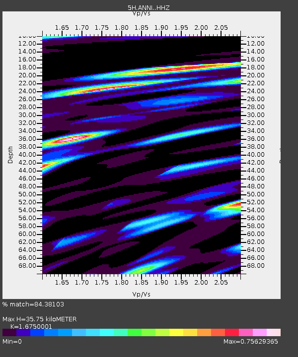
| Estimated Moho Depth: |
35.75 km |
| Estimated Crust Vp/Vs: |
1.68 |
| Assumed Crust Vp: |
6.565 km/s |
| Estimated Crust Vs: |
3.919 km/s |
| Estimated Crust Poisson's Ratio: |
0.22 |
|
| Radial Match: |
84.38103 % |
| Radial Bump: |
380 |
| Transverse Match: |
78.60104 % |
| Transverse Bump: |
400 |
| SOD ConfigId: |
13570011 |
| Insert Time: |
2019-04-30 01:23:13.674 +0000 |
| GWidth: |
2.5 |
| Max Bumps: |
400 |
| Tol: |
0.001 |
|

Signal To Noise
| Channel | StoN | STA | LTA |
| 5H:ANNI: :HHZ:20180402T13:49:16.769998Z | 6.2944136 | 1.7764262E-6 | 2.822227E-7 |
| 5H:ANNI: :HHN:20180402T13:49:16.769998Z | 3.3626387 | 9.3307295E-7 | 2.7748237E-7 |
| 5H:ANNI: :HHE:20180402T13:49:16.769998Z | 3.8422866 | 3.6933687E-7 | 9.612424E-8 |
| Arrivals |
| Ps | 3.9 SECOND |
| PpPs | 14 SECOND |
| PsPs/PpSs | 18 SECOND |


