You are here: Home > Network List > AE - Arizona Broadband Seismic Network Stations List
> Station BABIT Valle/Cataract Creek > Earthquake Result Viewer
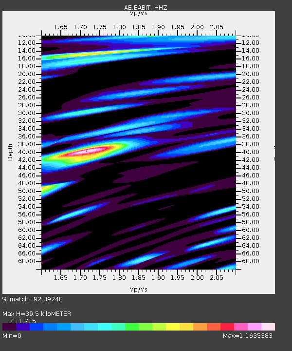
BABIT Valle/Cataract Creek - Earthquake Result Viewer
| Earthquake location: |
Southern Bolivia |
| Earthquake latitude/longitude: |
-20.7/-63.0 |
| Earthquake time(UTC): |
2018/04/02 (092) 13:40:34 GMT |
| Earthquake Depth: |
562 km |
| Earthquake Magnitude: |
6.8 Mww |
| Earthquake Catalog/Contributor: |
NEIC PDE/us |
|
| Network: |
AE Arizona Broadband Seismic Network |
| Station: |
BABIT Valle/Cataract Creek |
| Lat/Lon: |
35.75 N/112.42 W |
| Elevation: |
1694 m |
|
| Distance: |
73.0 deg |
| Az: |
319.774 deg |
| Baz: |
131.971 deg |
| Ray Param: |
0.05141773 |
| Estimated Moho Depth: |
39.5 km |
| Estimated Crust Vp/Vs: |
1.72 |
| Assumed Crust Vp: |
6.276 km/s |
| Estimated Crust Vs: |
3.659 km/s |
| Estimated Crust Poisson's Ratio: |
0.24 |
|
| Radial Match: |
92.39248 % |
| Radial Bump: |
400 |
| Transverse Match: |
79.76221 % |
| Transverse Bump: |
400 |
| SOD ConfigId: |
13570011 |
| Insert Time: |
2019-04-30 01:23:32.147 +0000 |
| GWidth: |
2.5 |
| Max Bumps: |
400 |
| Tol: |
0.001 |
|

Signal To Noise
| Channel | StoN | STA | LTA |
| AE:BABIT: :HHZ:20180402T13:50:37.369973Z | 4.9150023 | 4.7446895E-7 | 9.653484E-8 |
| AE:BABIT: :HHN:20180402T13:50:37.369973Z | 1.8282684 | 1.8196884E-7 | 9.95307E-8 |
| AE:BABIT: :HHE:20180402T13:50:37.369973Z | 2.0587337 | 1.5747442E-7 | 7.649091E-8 |
| Arrivals |
| Ps | 4.6 SECOND |
| PpPs | 17 SECOND |
| PsPs/PpSs | 21 SECOND |


