You are here: Home > Network List > CI - Caltech Regional Seismic Network Stations List
> Station DGR Domenigoni Reservoir, California, USA > Earthquake Result Viewer
DGR Domenigoni Reservoir, California, USA - Earthquake Result Viewer
| Earthquake location: |
Southern Bolivia |
| Earthquake latitude/longitude: |
-20.7/-63.0 |
| Earthquake time(UTC): |
2018/04/02 (092) 13:40:34 GMT |
| Earthquake Depth: |
562 km |
| Earthquake Magnitude: |
6.8 Mww |
| Earthquake Catalog/Contributor: |
NEIC PDE/us |
|
| Network: |
CI Caltech Regional Seismic Network |
| Station: |
DGR Domenigoni Reservoir, California, USA |
| Lat/Lon: |
33.65 N/117.01 W |
| Elevation: |
609 m |
|
| Distance: |
74.6 deg |
| Az: |
315.575 deg |
| Baz: |
128.198 deg |
| Ray Param: |
0.050424375 |
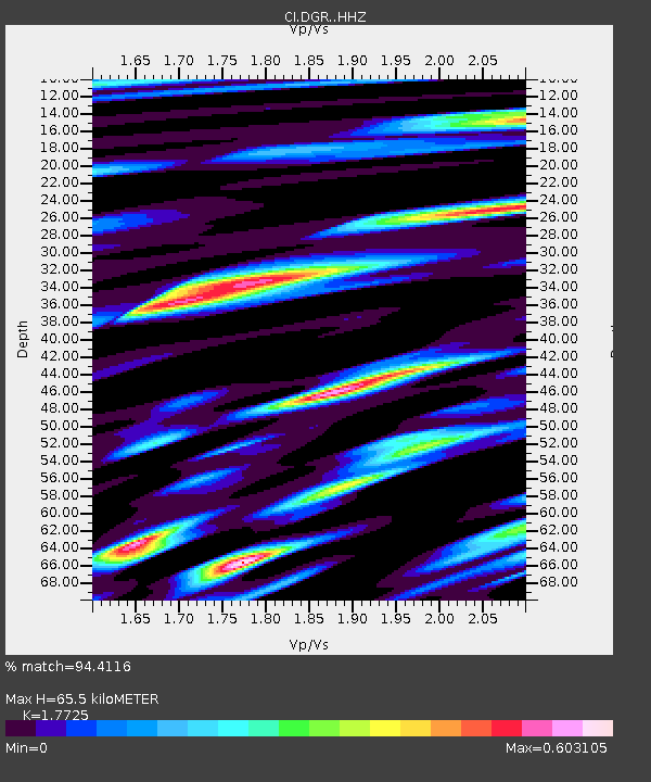
| Estimated Moho Depth: |
65.5 km |
| Estimated Crust Vp/Vs: |
1.77 |
| Assumed Crust Vp: |
6.264 km/s |
| Estimated Crust Vs: |
3.534 km/s |
| Estimated Crust Poisson's Ratio: |
0.27 |
|
| Radial Match: |
94.4116 % |
| Radial Bump: |
400 |
| Transverse Match: |
90.91657 % |
| Transverse Bump: |
400 |
| SOD ConfigId: |
13570011 |
| Insert Time: |
2019-04-30 01:25:03.443 +0000 |
| GWidth: |
2.5 |
| Max Bumps: |
400 |
| Tol: |
0.001 |
|

Signal To Noise
| Channel | StoN | STA | LTA |
| CI:DGR: :HHZ:20180402T13:50:46.10801Z | 4.969255 | 6.3813354E-7 | 1.2841633E-7 |
| CI:DGR: :HHN:20180402T13:50:46.10801Z | 4.509315 | 2.0773702E-7 | 4.6068422E-8 |
| CI:DGR: :HHE:20180402T13:50:46.10801Z | 1.3082641 | 9.0725614E-8 | 6.934808E-8 |
| Arrivals |
| Ps | 8.3 SECOND |
| PpPs | 28 SECOND |
| PsPs/PpSs | 36 SECOND |


