You are here: Home > Network List > TA - USArray Transportable Network (new EarthScope stations) Stations List
> Station K14A Jones Ranch, Declo, ID, USA > Earthquake Result Viewer
K14A Jones Ranch, Declo, ID, USA - Earthquake Result Viewer
| Earthquake location: |
Andreanof Islands, Aleutian Is. |
| Earthquake latitude/longitude: |
50.3/-177.5 |
| Earthquake time(UTC): |
2007/08/15 (227) 20:22:11 GMT |
| Earthquake Depth: |
9.0 km |
| Earthquake Magnitude: |
6.3 MB, 6.2 MS, 6.4 MW, 5.9 ML |
| Earthquake Catalog/Contributor: |
WHDF/NEIC |
|
| Network: |
TA USArray Transportable Network (new EarthScope stations) |
| Station: |
K14A Jones Ranch, Declo, ID, USA |
| Lat/Lon: |
42.55 N/113.18 W |
| Elevation: |
1387 m |
|
| Distance: |
43.8 deg |
| Az: |
74.361 deg |
| Baz: |
303.354 deg |
| Ray Param: |
0.07233153 |
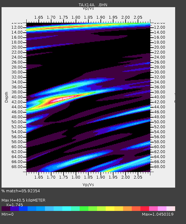
| Estimated Moho Depth: |
40.5 km |
| Estimated Crust Vp/Vs: |
1.75 |
| Assumed Crust Vp: |
6.279 km/s |
| Estimated Crust Vs: |
3.598 km/s |
| Estimated Crust Poisson's Ratio: |
0.26 |
|
| Radial Match: |
85.92354 % |
| Radial Bump: |
400 |
| Transverse Match: |
74.33173 % |
| Transverse Bump: |
400 |
| SOD ConfigId: |
2564 |
| Insert Time: |
2010-03-06 10:15:52.724 +0000 |
| GWidth: |
2.5 |
| Max Bumps: |
400 |
| Tol: |
0.001 |
|
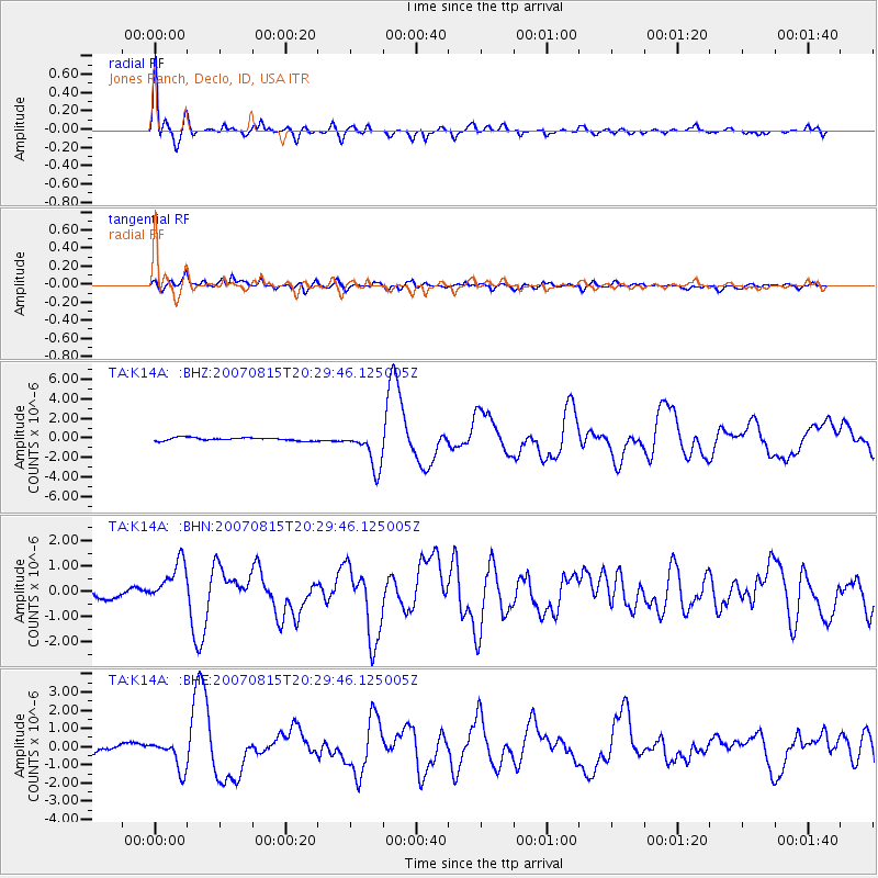
Signal To Noise
| Channel | StoN | STA | LTA |
| TA:K14A: :BHN:20070815T20:29:46.125005Z | 5.374572 | 8.549228E-7 | 1.5906808E-7 |
| TA:K14A: :BHE:20070815T20:29:46.125005Z | 2.9836195 | 8.24047E-7 | 2.7619038E-7 |
| TA:K14A: :BHZ:20070815T20:29:46.125005Z | 12.517901 | 1.9704805E-6 | 1.5741301E-7 |
| Arrivals |
| Ps | 5.1 SECOND |
| PpPs | 17 SECOND |
| PsPs/PpSs | 22 SECOND |


