You are here: Home > Network List > CN - Canadian National Seismograph Network Stations List
> Station ULM LAC DU BONNET, MB > Earthquake Result Viewer
ULM LAC DU BONNET, MB - Earthquake Result Viewer
| Earthquake location: |
Southern Bolivia |
| Earthquake latitude/longitude: |
-20.7/-63.0 |
| Earthquake time(UTC): |
2018/04/02 (092) 13:40:34 GMT |
| Earthquake Depth: |
562 km |
| Earthquake Magnitude: |
6.8 Mww |
| Earthquake Catalog/Contributor: |
NEIC PDE/us |
|
| Network: |
CN Canadian National Seismograph Network |
| Station: |
ULM LAC DU BONNET, MB |
| Lat/Lon: |
50.25 N/95.88 W |
| Elevation: |
251 m |
|
| Distance: |
76.3 deg |
| Az: |
338.995 deg |
| Baz: |
148.472 deg |
| Ray Param: |
0.049283687 |
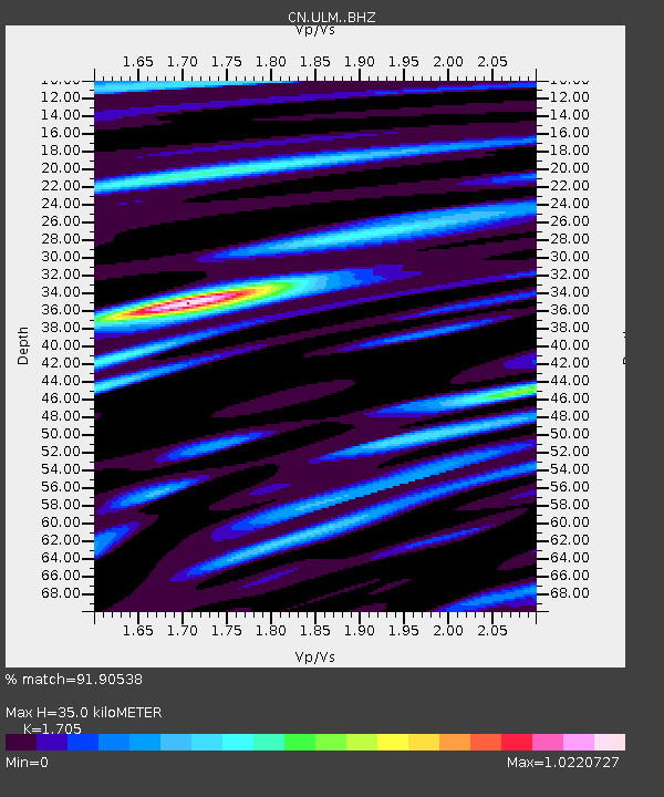
| Estimated Moho Depth: |
35.0 km |
| Estimated Crust Vp/Vs: |
1.71 |
| Assumed Crust Vp: |
6.459 km/s |
| Estimated Crust Vs: |
3.789 km/s |
| Estimated Crust Poisson's Ratio: |
0.24 |
|
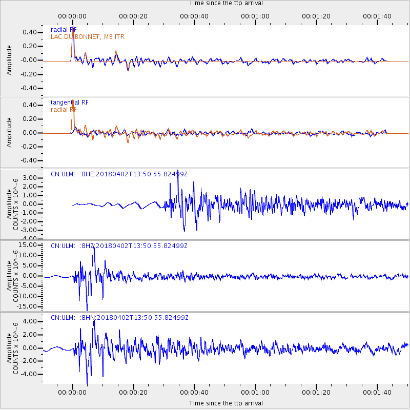
| Radial Match: |
91.90538 % |
| Radial Bump: |
398 |
| Transverse Match: |
78.396965 % |
| Transverse Bump: |
400 |
| SOD ConfigId: |
13570011 |
| Insert Time: |
2019-04-30 01:26:20.982 +0000 |
| GWidth: |
2.5 |
| Max Bumps: |
400 |
| Tol: |
0.001 |
|
Signal To Noise
| Channel | StoN | STA | LTA |
| CN:ULM: :BHZ:20180402T13:50:55.82499Z | 20.28834 | 4.6490745E-6 | 2.2915006E-7 |
| CN:ULM: :BHN:20180402T13:50:55.82499Z | 6.609874 | 1.4699827E-6 | 2.2239196E-7 |
| CN:ULM: :BHE:20180402T13:50:55.82499Z | 5.65495 | 9.792947E-7 | 1.7317475E-7 |
| Arrivals |
| Ps | 3.9 SECOND |
| PpPs | 14 SECOND |
| PsPs/PpSs | 18 SECOND |


