You are here: Home > Network List > N4 - Central and EAstern US Network Stations List
> Station B35B Bob, Littlefork, MN, USA > Earthquake Result Viewer
B35B Bob, Littlefork, MN, USA - Earthquake Result Viewer
| Earthquake location: |
Southern Bolivia |
| Earthquake latitude/longitude: |
-20.7/-63.0 |
| Earthquake time(UTC): |
2018/04/02 (092) 13:40:34 GMT |
| Earthquake Depth: |
562 km |
| Earthquake Magnitude: |
6.8 Mww |
| Earthquake Catalog/Contributor: |
NEIC PDE/us |
|
| Network: |
N4 Central and EAstern US Network |
| Station: |
B35B Bob, Littlefork, MN, USA |
| Lat/Lon: |
48.36 N/93.73 W |
| Elevation: |
354 m |
|
| Distance: |
74.0 deg |
| Az: |
339.248 deg |
| Baz: |
150.162 deg |
| Ray Param: |
0.05080091 |
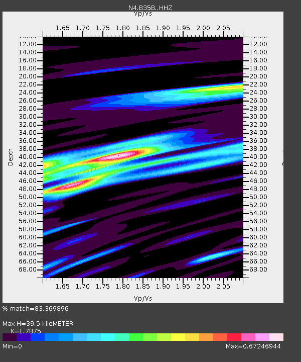
| Estimated Moho Depth: |
39.5 km |
| Estimated Crust Vp/Vs: |
1.79 |
| Assumed Crust Vp: |
6.419 km/s |
| Estimated Crust Vs: |
3.591 km/s |
| Estimated Crust Poisson's Ratio: |
0.27 |
|
| Radial Match: |
83.369896 % |
| Radial Bump: |
318 |
| Transverse Match: |
66.95771 % |
| Transverse Bump: |
400 |
| SOD ConfigId: |
13570011 |
| Insert Time: |
2019-04-30 01:28:22.964 +0000 |
| GWidth: |
2.5 |
| Max Bumps: |
400 |
| Tol: |
0.001 |
|

Signal To Noise
| Channel | StoN | STA | LTA |
| N4:B35B: :HHZ:20180402T13:50:42.800027Z | 13.598778 | 4.2492215E-6 | 3.1247083E-7 |
| N4:B35B: :HHN:20180402T13:50:42.800027Z | 8.990148 | 2.2363636E-6 | 2.4875717E-7 |
| N4:B35B: :HHE:20180402T13:50:42.800027Z | 7.446989 | 1.438796E-6 | 1.9320507E-7 |
| Arrivals |
| Ps | 5.0 SECOND |
| PpPs | 17 SECOND |
| PsPs/PpSs | 22 SECOND |


