You are here: Home > Network List > TA - USArray Transportable Network (new EarthScope stations) Stations List
> Station K14A Jones Ranch, Declo, ID, USA > Earthquake Result Viewer
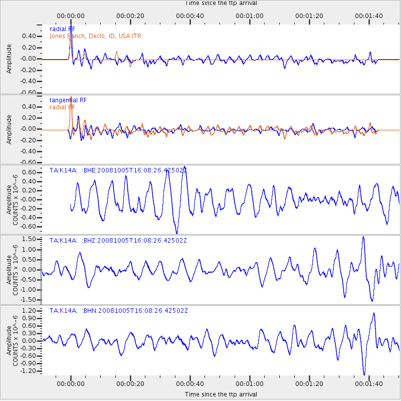
K14A Jones Ranch, Declo, ID, USA - Earthquake Result Viewer
*The percent match for this event was below the threshold and hence no stack was calculated.
| Earthquake location: |
Tajikistan-Xinjiang Border Reg. |
| Earthquake latitude/longitude: |
39.4/73.7 |
| Earthquake time(UTC): |
2008/10/05 (279) 15:55:24 GMT |
| Earthquake Depth: |
35 km |
| Earthquake Magnitude: |
5.9 MB |
| Earthquake Catalog/Contributor: |
WHDF/NEIC |
|
| Network: |
TA USArray Transportable Network (new EarthScope stations) |
| Station: |
K14A Jones Ranch, Declo, ID, USA |
| Lat/Lon: |
42.55 N/113.18 W |
| Elevation: |
1387 m |
|
| Distance: |
98.2 deg |
| Az: |
5.101 deg |
| Baz: |
354.648 deg |
| Ray Param: |
$rayparam |
*The percent match for this event was below the threshold and hence was not used in the summary stack. |
|
| Radial Match: |
61.313313 % |
| Radial Bump: |
400 |
| Transverse Match: |
57.292164 % |
| Transverse Bump: |
322 |
| SOD ConfigId: |
2560 |
| Insert Time: |
2010-03-06 10:17:12.289 +0000 |
| GWidth: |
2.5 |
| Max Bumps: |
400 |
| Tol: |
0.001 |
|
Signal To Noise
| Channel | StoN | STA | LTA |
| TA:K14A: :BHZ:20081005T16:08:26.42502Z | 1.6690522 | 4.6628895E-7 | 2.793735E-7 |
| TA:K14A: :BHN:20081005T16:08:26.42502Z | 1.555079 | 2.2969904E-7 | 1.4770893E-7 |
| TA:K14A: :BHE:20081005T16:08:26.42502Z | 1.6110204 | 4.1129147E-7 | 2.5529874E-7 |
| Arrivals |
| Ps | |
| PpPs | |
| PsPs/PpSs | |


