You are here: Home > Network List > N4 - Central and EAstern US Network Stations List
> Station W50A Signal Mountain, TN, USA > Earthquake Result Viewer
W50A Signal Mountain, TN, USA - Earthquake Result Viewer
| Earthquake location: |
Southern Bolivia |
| Earthquake latitude/longitude: |
-20.7/-63.0 |
| Earthquake time(UTC): |
2018/04/02 (092) 13:40:34 GMT |
| Earthquake Depth: |
562 km |
| Earthquake Magnitude: |
6.8 Mww |
| Earthquake Catalog/Contributor: |
NEIC PDE/us |
|
| Network: |
N4 Central and EAstern US Network |
| Station: |
W50A Signal Mountain, TN, USA |
| Lat/Lon: |
35.20 N/85.31 W |
| Elevation: |
587 m |
|
| Distance: |
59.4 deg |
| Az: |
338.85 deg |
| Baz: |
155.631 deg |
| Ray Param: |
0.059944693 |
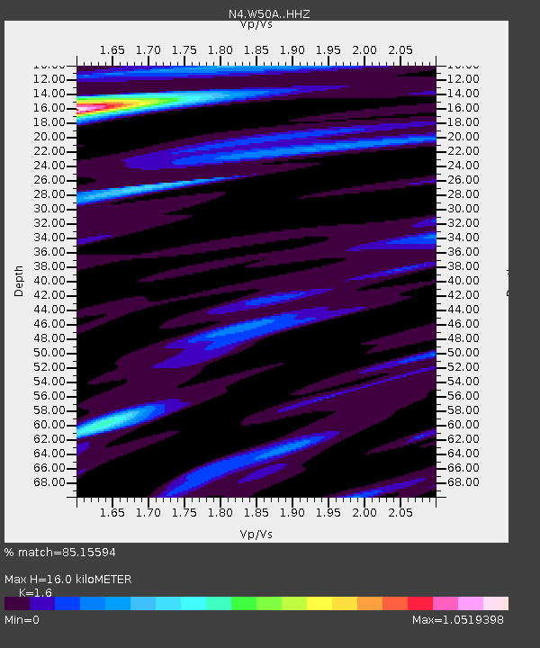
| Estimated Moho Depth: |
16.0 km |
| Estimated Crust Vp/Vs: |
1.60 |
| Assumed Crust Vp: |
6.35 km/s |
| Estimated Crust Vs: |
3.969 km/s |
| Estimated Crust Poisson's Ratio: |
0.18 |
|
| Radial Match: |
85.15594 % |
| Radial Bump: |
400 |
| Transverse Match: |
62.592133 % |
| Transverse Bump: |
400 |
| SOD ConfigId: |
13570011 |
| Insert Time: |
2019-04-30 01:29:48.463 +0000 |
| GWidth: |
2.5 |
| Max Bumps: |
400 |
| Tol: |
0.001 |
|

Signal To Noise
| Channel | StoN | STA | LTA |
| N4:W50A: :HHZ:20180402T13:49:13.429971Z | 20.206068 | 3.0548074E-6 | 1.5118268E-7 |
| N4:W50A: :HHN:20180402T13:49:13.429971Z | 13.11556 | 1.1863544E-6 | 9.045397E-8 |
| N4:W50A: :HHE:20180402T13:49:13.429971Z | 2.4249125 | 4.494302E-7 | 1.8533872E-7 |
| Arrivals |
| Ps | 1.6 SECOND |
| PpPs | 6.2 SECOND |
| PsPs/PpSs | 7.8 SECOND |


