You are here: Home > Network List > US - United States National Seismic Network Stations List
> Station MSO Missoula, Montana, USA > Earthquake Result Viewer
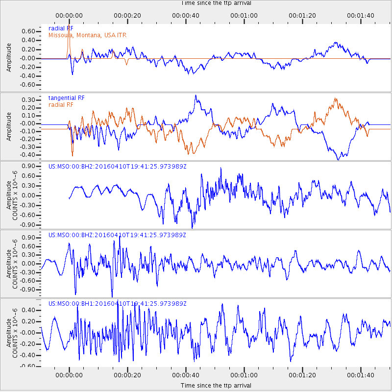
MSO Missoula, Montana, USA - Earthquake Result Viewer
*The percent match for this event was below the threshold and hence no stack was calculated.
| Earthquake location: |
Rat Islands, Aleutian Islands |
| Earthquake latitude/longitude: |
51.1/179.5 |
| Earthquake time(UTC): |
2016/04/10 (101) 19:34:02 GMT |
| Earthquake Depth: |
19 km |
| Earthquake Magnitude: |
5.6 MWW, 5.3 ML, 5.4 MWB, 5.6 MWC, 5.7 ML |
| Earthquake Catalog/Contributor: |
NEIC PDE/NEIC COMCAT |
|
| Network: |
US United States National Seismic Network |
| Station: |
MSO Missoula, Montana, USA |
| Lat/Lon: |
46.83 N/113.94 W |
| Elevation: |
1264 m |
|
| Distance: |
42.5 deg |
| Az: |
68.683 deg |
| Baz: |
301.238 deg |
| Ray Param: |
$rayparam |
*The percent match for this event was below the threshold and hence was not used in the summary stack. |
|
| Radial Match: |
45.55088 % |
| Radial Bump: |
400 |
| Transverse Match: |
43.60968 % |
| Transverse Bump: |
400 |
| SOD ConfigId: |
1475611 |
| Insert Time: |
2016-05-15 15:52:18.730 +0000 |
| GWidth: |
2.5 |
| Max Bumps: |
400 |
| Tol: |
0.001 |
|
Signal To Noise
| Channel | StoN | STA | LTA |
| US:MSO:00:BHZ:20160410T19:41:25.973989Z | 2.2177148 | 4.5388822E-7 | 2.0466483E-7 |
| US:MSO:00:BH1:20160410T19:41:25.973989Z | 1.4293486 | 2.1077194E-7 | 1.4746014E-7 |
| US:MSO:00:BH2:20160410T19:41:25.973989Z | 3.6207595 | 4.7563734E-7 | 1.3136396E-7 |
| Arrivals |
| Ps | |
| PpPs | |
| PsPs/PpSs | |


