You are here: Home > Network List > PE - Penn State Network Stations List
> Station PAMP Mt. Pisgah State Park, Troy, PA > Earthquake Result Viewer
PAMP Mt. Pisgah State Park, Troy, PA - Earthquake Result Viewer
| Earthquake location: |
Southern Bolivia |
| Earthquake latitude/longitude: |
-20.7/-63.0 |
| Earthquake time(UTC): |
2018/04/02 (092) 13:40:34 GMT |
| Earthquake Depth: |
562 km |
| Earthquake Magnitude: |
6.8 Mww |
| Earthquake Catalog/Contributor: |
NEIC PDE/us |
|
| Network: |
PE Penn State Network |
| Station: |
PAMP Mt. Pisgah State Park, Troy, PA |
| Lat/Lon: |
41.81 N/76.67 W |
| Elevation: |
348 m |
|
| Distance: |
63.4 deg |
| Az: |
348.619 deg |
| Baz: |
165.689 deg |
| Ray Param: |
0.05748055 |
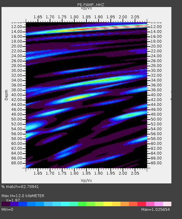
| Estimated Moho Depth: |
12.0 km |
| Estimated Crust Vp/Vs: |
1.97 |
| Assumed Crust Vp: |
6.121 km/s |
| Estimated Crust Vs: |
3.107 km/s |
| Estimated Crust Poisson's Ratio: |
0.33 |
|
| Radial Match: |
82.78941 % |
| Radial Bump: |
400 |
| Transverse Match: |
74.35149 % |
| Transverse Bump: |
400 |
| SOD ConfigId: |
13570011 |
| Insert Time: |
2019-04-30 01:32:11.019 +0000 |
| GWidth: |
2.5 |
| Max Bumps: |
400 |
| Tol: |
0.001 |
|

Signal To Noise
| Channel | StoN | STA | LTA |
| PE:PAMP: :HHZ:20180402T13:49:39.275002Z | 10.108598 | 2.9117707E-6 | 2.8804894E-7 |
| PE:PAMP: :HHN:20180402T13:49:39.275002Z | 6.0176044 | 1.4435192E-6 | 2.398827E-7 |
| PE:PAMP: :HHE:20180402T13:49:39.275002Z | 4.2062526 | 8.969579E-7 | 2.1324395E-7 |
| Arrivals |
| Ps | 2.0 SECOND |
| PpPs | 5.6 SECOND |
| PsPs/PpSs | 7.6 SECOND |


