You are here: Home > Network List > TC - Red Sismólogica Nacional de Costa Rica Stations List
> Station MARA Maravilla > Earthquake Result Viewer
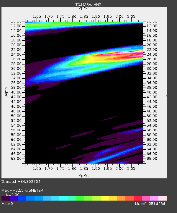
MARA Maravilla - Earthquake Result Viewer
| Earthquake location: |
Southern Bolivia |
| Earthquake latitude/longitude: |
-20.7/-63.0 |
| Earthquake time(UTC): |
2018/04/02 (092) 13:40:34 GMT |
| Earthquake Depth: |
562 km |
| Earthquake Magnitude: |
6.8 Mww |
| Earthquake Catalog/Contributor: |
NEIC PDE/us |
|
| Network: |
TC Red Sismólogica Nacional de Costa Rica |
| Station: |
MARA Maravilla |
| Lat/Lon: |
10.02 N/85.43 W |
| Elevation: |
629 m |
|
| Distance: |
37.6 deg |
| Az: |
322.032 deg |
| Baz: |
144.199 deg |
| Ray Param: |
0.07319669 |
| Estimated Moho Depth: |
22.5 km |
| Estimated Crust Vp/Vs: |
2.09 |
| Assumed Crust Vp: |
6.597 km/s |
| Estimated Crust Vs: |
3.157 km/s |
| Estimated Crust Poisson's Ratio: |
0.35 |
|
| Radial Match: |
84.302704 % |
| Radial Bump: |
400 |
| Transverse Match: |
50.259098 % |
| Transverse Bump: |
400 |
| SOD ConfigId: |
13570011 |
| Insert Time: |
2019-04-30 01:33:50.173 +0000 |
| GWidth: |
2.5 |
| Max Bumps: |
400 |
| Tol: |
0.001 |
|

Signal To Noise
| Channel | StoN | STA | LTA |
| TC:MARA: :HHZ:20180402T13:46:32.039987Z | 6.481345 | 6.1895676E-6 | 9.549819E-7 |
| TC:MARA: :HHN:20180402T13:46:32.039987Z | 2.3658423 | 2.9098733E-6 | 1.2299523E-6 |
| TC:MARA: :HHE:20180402T13:46:32.039987Z | 1.6105629 | 1.5778095E-6 | 9.796634E-7 |
| Arrivals |
| Ps | 3.9 SECOND |
| PpPs | 9.9 SECOND |
| PsPs/PpSs | 14 SECOND |


