You are here: Home > Network List > TA - USArray Transportable Network (new EarthScope stations) Stations List
> Station K14A Jones Ranch, Declo, ID, USA > Earthquake Result Viewer
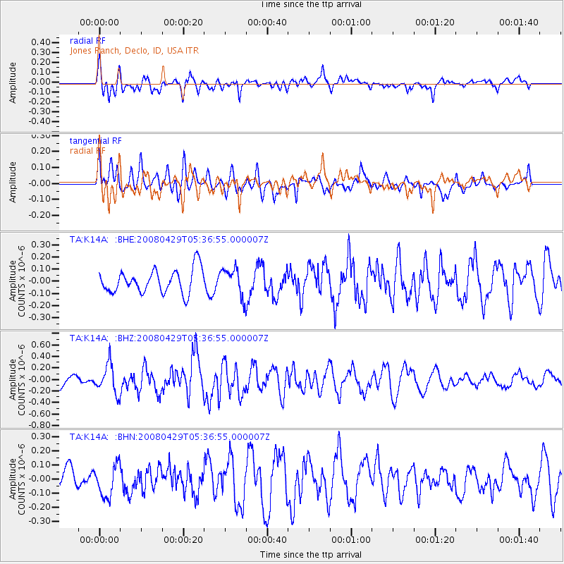
K14A Jones Ranch, Declo, ID, USA - Earthquake Result Viewer
*The percent match for this event was below the threshold and hence no stack was calculated.
| Earthquake location: |
Hokkaido, Japan Region |
| Earthquake latitude/longitude: |
41.5/142.0 |
| Earthquake time(UTC): |
2008/04/29 (120) 05:26:04 GMT |
| Earthquake Depth: |
47 km |
| Earthquake Magnitude: |
5.5 MB, 5.2 MS, 5.8 MW, 5.8 MW |
| Earthquake Catalog/Contributor: |
WHDF/NEIC |
|
| Network: |
TA USArray Transportable Network (new EarthScope stations) |
| Station: |
K14A Jones Ranch, Declo, ID, USA |
| Lat/Lon: |
42.55 N/113.18 W |
| Elevation: |
1387 m |
|
| Distance: |
72.4 deg |
| Az: |
48.557 deg |
| Baz: |
310.314 deg |
| Ray Param: |
$rayparam |
*The percent match for this event was below the threshold and hence was not used in the summary stack. |
|
| Radial Match: |
68.45993 % |
| Radial Bump: |
400 |
| Transverse Match: |
48.349712 % |
| Transverse Bump: |
400 |
| SOD ConfigId: |
2504 |
| Insert Time: |
2010-03-06 10:18:38.067 +0000 |
| GWidth: |
2.5 |
| Max Bumps: |
400 |
| Tol: |
0.001 |
|
Signal To Noise
| Channel | StoN | STA | LTA |
| TA:K14A: :BHZ:20080429T05:36:55.000007Z | 2.585819 | 2.6025617E-7 | 1.0064749E-7 |
| TA:K14A: :BHN:20080429T05:36:55.000007Z | 1.4949622 | 1.1320083E-7 | 7.572153E-8 |
| TA:K14A: :BHE:20080429T05:36:55.000007Z | 1.2257717 | 1.1876985E-7 | 9.689394E-8 |
| Arrivals |
| Ps | |
| PpPs | |
| PsPs/PpSs | |


