You are here: Home > Network List > XU16 - USGS NEHRP Proposal 2016-2018 - Greeley, CO Stations List
> Station LS02 Lasalle West, CO, USA > Earthquake Result Viewer
LS02 Lasalle West, CO, USA - Earthquake Result Viewer
| Earthquake location: |
Southern Bolivia |
| Earthquake latitude/longitude: |
-20.7/-63.0 |
| Earthquake time(UTC): |
2018/04/02 (092) 13:40:34 GMT |
| Earthquake Depth: |
562 km |
| Earthquake Magnitude: |
6.8 Mww |
| Earthquake Catalog/Contributor: |
NEIC PDE/us |
|
| Network: |
XU USGS NEHRP Proposal 2016-2018 - Greeley, CO |
| Station: |
LS02 Lasalle West, CO, USA |
| Lat/Lon: |
40.25 N/104.71 W |
| Elevation: |
1530 m |
|
| Distance: |
72.0 deg |
| Az: |
327.633 deg |
| Baz: |
139.077 deg |
| Ray Param: |
0.052097652 |
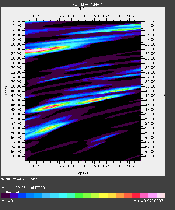
| Estimated Moho Depth: |
22.25 km |
| Estimated Crust Vp/Vs: |
1.64 |
| Assumed Crust Vp: |
6.306 km/s |
| Estimated Crust Vs: |
3.833 km/s |
| Estimated Crust Poisson's Ratio: |
0.21 |
|
| Radial Match: |
87.30566 % |
| Radial Bump: |
400 |
| Transverse Match: |
72.02343 % |
| Transverse Bump: |
400 |
| SOD ConfigId: |
13570011 |
| Insert Time: |
2019-04-30 01:35:22.167 +0000 |
| GWidth: |
2.5 |
| Max Bumps: |
400 |
| Tol: |
0.001 |
|

Signal To Noise
| Channel | StoN | STA | LTA |
| XU:LS02: :HHZ:20180402T13:50:31.233987Z | 8.11412 | 1.576268E-6 | 1.9426234E-7 |
| XU:LS02: :HH1:20180402T13:50:31.233987Z | 1.1899917 | 5.4925647E-7 | 4.6156325E-7 |
| XU:LS02: :HH2:20180402T13:50:31.233987Z | 0.9712236 | 4.884669E-7 | 5.0293977E-7 |
| Arrivals |
| Ps | 2.4 SECOND |
| PpPs | 9.0 SECOND |
| PsPs/PpSs | 11 SECOND |


