You are here: Home > Network List > XW17 - Broadband seismic experiment in NE Uganda to investigate plume-lithosphere inter Stations List
> Station GULU Bungatira Sub-County Offices > Earthquake Result Viewer
GULU Bungatira Sub-County Offices - Earthquake Result Viewer
| Earthquake location: |
Southern Bolivia |
| Earthquake latitude/longitude: |
-20.7/-63.0 |
| Earthquake time(UTC): |
2018/04/02 (092) 13:40:34 GMT |
| Earthquake Depth: |
562 km |
| Earthquake Magnitude: |
6.8 Mww |
| Earthquake Catalog/Contributor: |
NEIC PDE/us |
|
| Network: |
XW Broadband seismic experiment in NE Uganda to investigate plume-lithosphere inter |
| Station: |
GULU Bungatira Sub-County Offices |
| Lat/Lon: |
2.88 N/32.28 E |
| Elevation: |
1059 m |
|
| Distance: |
96.0 deg |
| Az: |
89.173 deg |
| Baz: |
249.65 deg |
| Ray Param: |
0.04003809 |
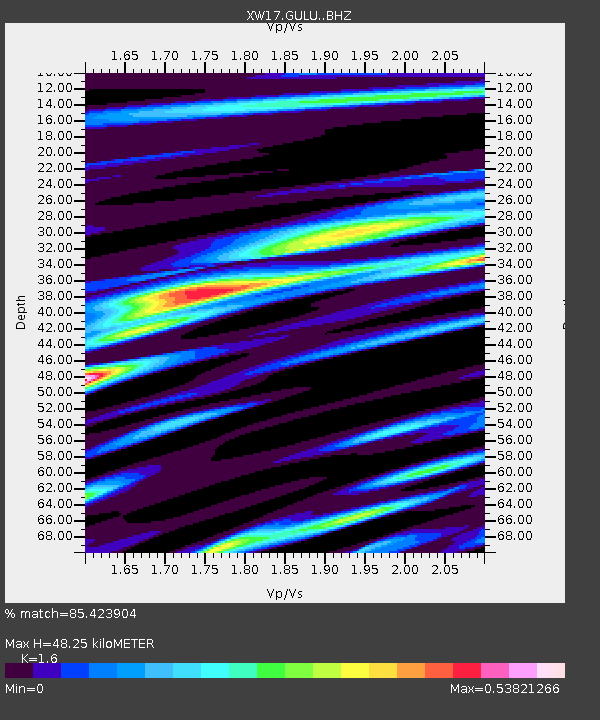
| Estimated Moho Depth: |
48.25 km |
| Estimated Crust Vp/Vs: |
1.60 |
| Assumed Crust Vp: |
6.642 km/s |
| Estimated Crust Vs: |
4.151 km/s |
| Estimated Crust Poisson's Ratio: |
0.18 |
|
| Radial Match: |
85.423904 % |
| Radial Bump: |
400 |
| Transverse Match: |
48.50823 % |
| Transverse Bump: |
400 |
| SOD ConfigId: |
13570011 |
| Insert Time: |
2019-04-30 01:35:22.768 +0000 |
| GWidth: |
2.5 |
| Max Bumps: |
400 |
| Tol: |
0.001 |
|

Signal To Noise
| Channel | StoN | STA | LTA |
| XW:GULU: :BHZ:20180402T13:52:30.725015Z | 2.6741204 | 1.5648584E-7 | 5.8518623E-8 |
| XW:GULU: :BHN:20180402T13:52:30.725015Z | 0.90201855 | 6.590012E-8 | 7.30585E-8 |
| XW:GULU: :BHE:20180402T13:52:30.725015Z | 1.4250599 | 8.6448985E-8 | 6.06634E-8 |
| Arrivals |
| Ps | 4.5 SECOND |
| PpPs | 18 SECOND |
| PsPs/PpSs | 23 SECOND |


