You are here: Home > Network List > WY - Yellowstone Wyoming Seismic Network Stations List
> Station YHH Holmes Hill, YNP, WY, USA > Earthquake Result Viewer
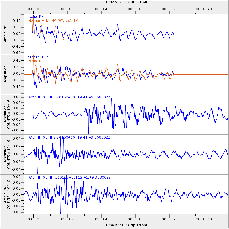
YHH Holmes Hill, YNP, WY, USA - Earthquake Result Viewer
*The percent match for this event was below the threshold and hence no stack was calculated.
| Earthquake location: |
Rat Islands, Aleutian Islands |
| Earthquake latitude/longitude: |
51.1/179.5 |
| Earthquake time(UTC): |
2016/04/10 (101) 19:34:02 GMT |
| Earthquake Depth: |
19 km |
| Earthquake Magnitude: |
5.6 MWW, 5.3 ML, 5.4 MWB, 5.6 MWC, 5.7 ML |
| Earthquake Catalog/Contributor: |
NEIC PDE/NEIC COMCAT |
|
| Network: |
WY Yellowstone Wyoming Seismic Network |
| Station: |
YHH Holmes Hill, YNP, WY, USA |
| Lat/Lon: |
44.79 N/110.85 W |
| Elevation: |
2717 m |
|
| Distance: |
45.5 deg |
| Az: |
69.479 deg |
| Baz: |
304.02 deg |
| Ray Param: |
$rayparam |
*The percent match for this event was below the threshold and hence was not used in the summary stack. |
|
| Radial Match: |
63.126354 % |
| Radial Bump: |
400 |
| Transverse Match: |
60.71871 % |
| Transverse Bump: |
400 |
| SOD ConfigId: |
1475611 |
| Insert Time: |
2016-05-15 15:54:01.691 +0000 |
| GWidth: |
2.5 |
| Max Bumps: |
400 |
| Tol: |
0.001 |
|
Signal To Noise
| Channel | StoN | STA | LTA |
| WY:YHH:01:HHZ:20160410T19:41:49.368002Z | 3.3500507 | 1.5585167E-8 | 4.652218E-9 |
| WY:YHH:01:HHN:20160410T19:41:49.368002Z | 1.4680663 | 6.9739308E-9 | 4.750419E-9 |
| WY:YHH:01:HHE:20160410T19:41:49.368002Z | 3.1400278 | 1.14171845E-8 | 3.636014E-9 |
| Arrivals |
| Ps | |
| PpPs | |
| PsPs/PpSs | |


