You are here: Home > Network List > TA - USArray Transportable Network (new EarthScope stations) Stations List
> Station W18A Petrified Forest, AZ, USA > Earthquake Result Viewer
W18A Petrified Forest, AZ, USA - Earthquake Result Viewer
| Earthquake location: |
Vanuatu Islands |
| Earthquake latitude/longitude: |
-13.5/167.0 |
| Earthquake time(UTC): |
2008/09/08 (252) 18:52:06 GMT |
| Earthquake Depth: |
110 km |
| Earthquake Magnitude: |
6.4 MB, 6.9 MW, 6.9 MW |
| Earthquake Catalog/Contributor: |
WHDF/NEIC |
|
| Network: |
TA USArray Transportable Network (new EarthScope stations) |
| Station: |
W18A Petrified Forest, AZ, USA |
| Lat/Lon: |
35.12 N/109.74 W |
| Elevation: |
1750 m |
|
| Distance: |
92.3 deg |
| Az: |
54.57 deg |
| Baz: |
255.203 deg |
| Ray Param: |
0.041429497 |
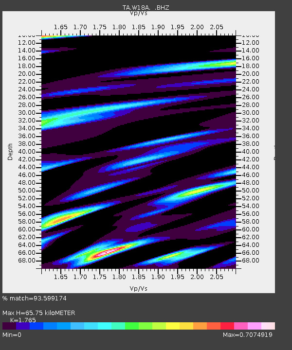
| Estimated Moho Depth: |
65.75 km |
| Estimated Crust Vp/Vs: |
1.76 |
| Assumed Crust Vp: |
6.496 km/s |
| Estimated Crust Vs: |
3.68 km/s |
| Estimated Crust Poisson's Ratio: |
0.26 |
|
| Radial Match: |
93.599174 % |
| Radial Bump: |
400 |
| Transverse Match: |
84.49032 % |
| Transverse Bump: |
400 |
| SOD ConfigId: |
2504 |
| Insert Time: |
2010-03-06 10:19:35.633 +0000 |
| GWidth: |
2.5 |
| Max Bumps: |
400 |
| Tol: |
0.001 |
|

Signal To Noise
| Channel | StoN | STA | LTA |
| TA:W18A: :BHZ:20080908T19:04:33.399016Z | 37.41974 | 2.7531476E-6 | 7.3574746E-8 |
| TA:W18A: :BHN:20080908T19:04:33.399016Z | 4.1784234 | 2.9160887E-7 | 6.9789216E-8 |
| TA:W18A: :BHE:20080908T19:04:33.399016Z | 10.23761 | 1.1044762E-6 | 1.0788418E-7 |
| Arrivals |
| Ps | 7.9 SECOND |
| PpPs | 27 SECOND |
| PsPs/PpSs | 35 SECOND |


