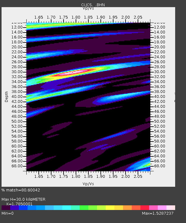
JCS Julian Camp Stevens, California, USA - Earthquake Result Viewer
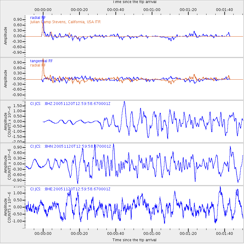
Earthquake location: Unimak Island Region, Alaska
Earthquake latitude/longitude: 53.8/-164.1
Earthquake time(UTC): 2005/11/20 (324) 12:53:02 GMT
Earthquake Depth: 30 km
Earthquake Magnitude: 5.7 MB, 5.8 MS, 6.2 MW, 6.0 MW
Earthquake Catalog/Contributor: WHDF/NEIC
Network: CI Caltech Regional Seismic Network
Station: JCS Julian Camp Stevens, California, USA
Lat/Lon: 33.09 N/116.60 W
Elevation: 1258 m
Distance: 39.3 deg
Az: 102.298 deg
Baz: 316.397 deg
Ray Param: 0.07500569
Estimated Moho Depth: 30.0 km
Estimated Crust Vp/Vs: 1.79
Assumed Crust Vp: 6.264 km/s
Estimated Crust Vs: 3.509 km/s
Estimated Crust Poisson's Ratio: 0.27
Radial Match: 80.60042 %
Radial Bump: 400
Transverse Match: 65.569534 %
Transverse Bump: 400
SOD ConfigId: 2669
Insert Time: 2010-02-26 01:54:05.039 +0000
GWidth: 2.5
Max Bumps: 400
Tol: 0.001

Signal To Noise

ChannelStoNSTALTA
CI:JCS: :BHN:20051120T12:59:58.670001Z1.50047411.6726916E-71.1147754E-7
CI:JCS: :BHE:20051120T12:59:58.670001Z1.12140583.0684456E-72.736249E-7
CI:JCS: :BHZ:20051120T12:59:58.670001Z2.65966063.1044007E-71.1672169E-7
Arrivals
Ps4.0 SECOND
PpPs12 SECOND
PsPs/PpSs16 SECOND