You are here: Home > Network List > TA - USArray Transportable Network (new EarthScope stations) Stations List
> Station W18A Petrified Forest, AZ, USA > Earthquake Result Viewer
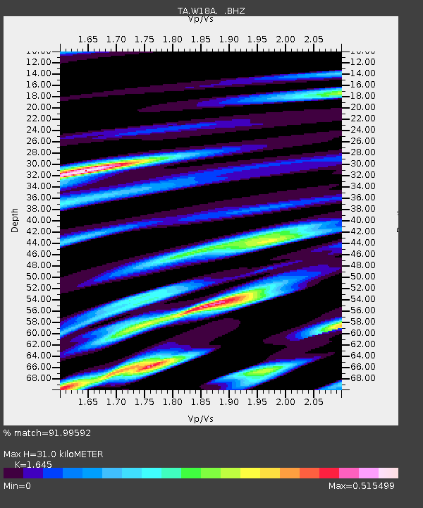
W18A Petrified Forest, AZ, USA - Earthquake Result Viewer
| Earthquake location: |
Santa Cruz Islands Region |
| Earthquake latitude/longitude: |
-11.0/164.5 |
| Earthquake time(UTC): |
2008/07/19 (201) 09:27:01 GMT |
| Earthquake Depth: |
11 km |
| Earthquake Magnitude: |
6.1 MB, 6.4 MS, 6.6 MW, 6.6 MW |
| Earthquake Catalog/Contributor: |
WHDF/NEIC |
|
| Network: |
TA USArray Transportable Network (new EarthScope stations) |
| Station: |
W18A Petrified Forest, AZ, USA |
| Lat/Lon: |
35.12 N/109.74 W |
| Elevation: |
1750 m |
|
| Distance: |
92.8 deg |
| Az: |
54.941 deg |
| Baz: |
258.598 deg |
| Ray Param: |
0.041377682 |
| Estimated Moho Depth: |
31.0 km |
| Estimated Crust Vp/Vs: |
1.64 |
| Assumed Crust Vp: |
6.496 km/s |
| Estimated Crust Vs: |
3.949 km/s |
| Estimated Crust Poisson's Ratio: |
0.21 |
|
| Radial Match: |
91.99592 % |
| Radial Bump: |
400 |
| Transverse Match: |
76.70548 % |
| Transverse Bump: |
400 |
| SOD ConfigId: |
2658 |
| Insert Time: |
2010-03-06 10:19:58.730 +0000 |
| GWidth: |
2.5 |
| Max Bumps: |
400 |
| Tol: |
0.001 |
|

Signal To Noise
| Channel | StoN | STA | LTA |
| TA:W18A: :BHZ:20080719T09:39:42.449014Z | 18.395369 | 1.2582851E-6 | 6.840227E-8 |
| TA:W18A: :BHN:20080719T09:39:42.449014Z | 1.6833682 | 1.2087166E-7 | 7.180346E-8 |
| TA:W18A: :BHE:20080719T09:39:42.449014Z | 5.401245 | 3.7955184E-7 | 7.027118E-8 |
| Arrivals |
| Ps | 3.1 SECOND |
| PpPs | 12 SECOND |
| PsPs/PpSs | 15 SECOND |


