You are here: Home > Network List > CI - Caltech Regional Seismic Network Stations List
> Station JCS Julian Camp Stevens, California, USA > Earthquake Result Viewer
JCS Julian Camp Stevens, California, USA - Earthquake Result Viewer
| Earthquake location: |
Chile-Bolivia Border Region |
| Earthquake latitude/longitude: |
-22.3/-67.9 |
| Earthquake time(UTC): |
2005/11/17 (321) 19:26:56 GMT |
| Earthquake Depth: |
163 km |
| Earthquake Magnitude: |
6.0 MB, 6.9 MW, 6.8 MW |
| Earthquake Catalog/Contributor: |
WHDF/NEIC |
|
| Network: |
CI Caltech Regional Seismic Network |
| Station: |
JCS Julian Camp Stevens, California, USA |
| Lat/Lon: |
33.09 N/116.60 W |
| Elevation: |
1258 m |
|
| Distance: |
72.1 deg |
| Az: |
318.472 deg |
| Baz: |
133.008 deg |
| Ray Param: |
0.05347538 |
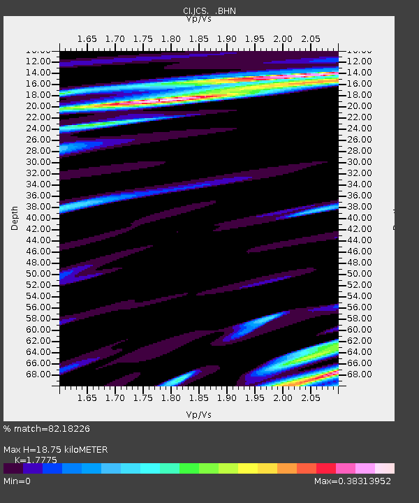
| Estimated Moho Depth: |
18.75 km |
| Estimated Crust Vp/Vs: |
1.78 |
| Assumed Crust Vp: |
6.264 km/s |
| Estimated Crust Vs: |
3.524 km/s |
| Estimated Crust Poisson's Ratio: |
0.27 |
|
| Radial Match: |
82.18226 % |
| Radial Bump: |
400 |
| Transverse Match: |
68.40843 % |
| Transverse Bump: |
400 |
| SOD ConfigId: |
2422 |
| Insert Time: |
2010-02-26 01:54:06.215 +0000 |
| GWidth: |
2.5 |
| Max Bumps: |
400 |
| Tol: |
0.001 |
|
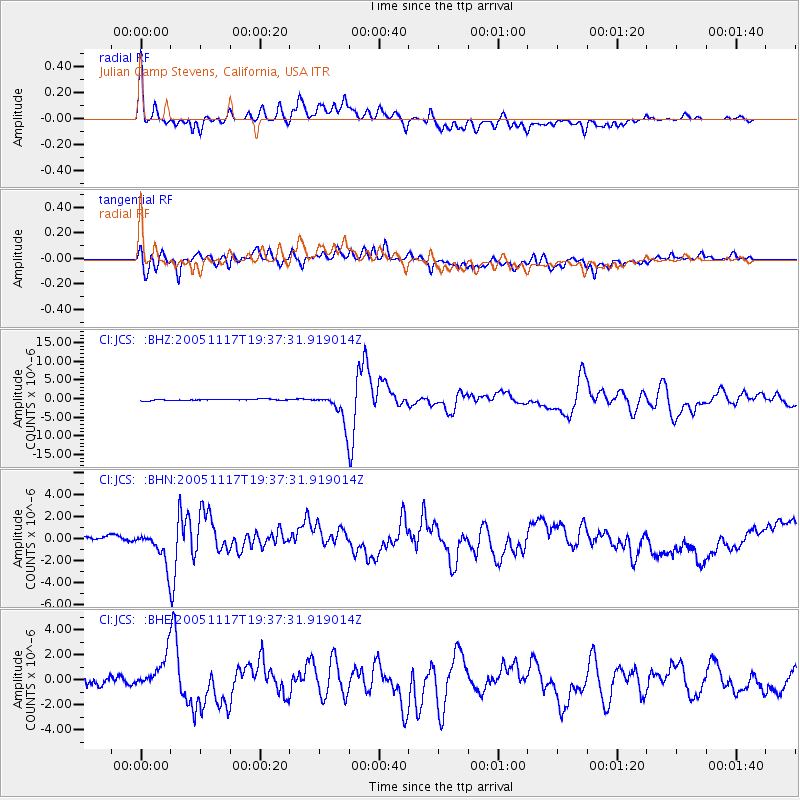
Signal To Noise
| Channel | StoN | STA | LTA |
| CI:JCS: :BHN:20051117T19:37:31.919014Z | 9.137488 | 1.5598632E-6 | 1.7071028E-7 |
| CI:JCS: :BHE:20051117T19:37:31.919014Z | 4.1685367 | 1.5111378E-6 | 3.6251038E-7 |
| CI:JCS: :BHZ:20051117T19:37:31.919014Z | 23.879787 | 4.0421974E-6 | 1.6927275E-7 |
| Arrivals |
| Ps | 2.4 SECOND |
| PpPs | 8.0 SECOND |
| PsPs/PpSs | 10 SECOND |


