You are here: Home > Network List > TA - USArray Transportable Network (new EarthScope stations) Stations List
> Station W18A Petrified Forest, AZ, USA > Earthquake Result Viewer
W18A Petrified Forest, AZ, USA - Earthquake Result Viewer
| Earthquake location: |
Near Coast Of Venezuela |
| Earthquake latitude/longitude: |
10.7/-67.9 |
| Earthquake time(UTC): |
2009/09/12 (255) 20:06:24 GMT |
| Earthquake Depth: |
10 km |
| Earthquake Magnitude: |
6.3 MB, 6.4 MS, 6.3 MW, 6.3 MW |
| Earthquake Catalog/Contributor: |
WHDF/NEIC |
|
| Network: |
TA USArray Transportable Network (new EarthScope stations) |
| Station: |
W18A Petrified Forest, AZ, USA |
| Lat/Lon: |
35.12 N/109.74 W |
| Elevation: |
1750 m |
|
| Distance: |
45.1 deg |
| Az: |
309.47 deg |
| Baz: |
112.258 deg |
| Ray Param: |
0.07151719 |
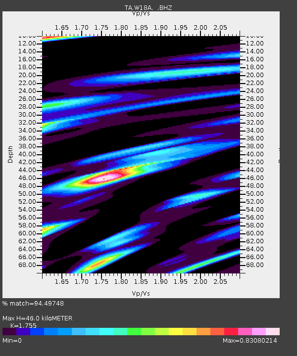
| Estimated Moho Depth: |
46.0 km |
| Estimated Crust Vp/Vs: |
1.75 |
| Assumed Crust Vp: |
6.496 km/s |
| Estimated Crust Vs: |
3.701 km/s |
| Estimated Crust Poisson's Ratio: |
0.26 |
|
| Radial Match: |
94.49748 % |
| Radial Bump: |
270 |
| Transverse Match: |
82.7781 % |
| Transverse Bump: |
400 |
| SOD ConfigId: |
2622 |
| Insert Time: |
2010-03-06 10:20:16.851 +0000 |
| GWidth: |
2.5 |
| Max Bumps: |
400 |
| Tol: |
0.001 |
|

Signal To Noise
| Channel | StoN | STA | LTA |
| TA:W18A: :BHZ:20090912T20:14:09.823992Z | 7.662813 | 9.5224755E-7 | 1.2426867E-7 |
| TA:W18A: :BHN:20090912T20:14:09.823992Z | 2.5486534 | 2.4040136E-7 | 9.432486E-8 |
| TA:W18A: :BHE:20090912T20:14:09.823992Z | 3.979198 | 4.8695284E-7 | 1.2237462E-7 |
| Arrivals |
| Ps | 5.7 SECOND |
| PpPs | 18 SECOND |
| PsPs/PpSs | 24 SECOND |


