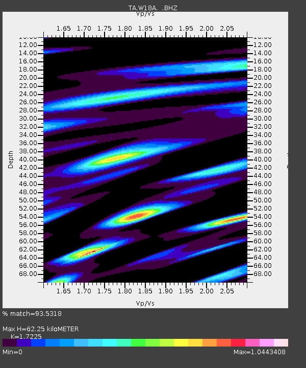
W18A Petrified Forest, AZ, USA - Earthquake Result Viewer

Earthquake location: Fox Islands, Aleutian Islands
Earthquake latitude/longitude: 52.6/-167.1
Earthquake time(UTC): 2009/10/13 (286) 20:21:53 GMT
Earthquake Depth: 14 km
Earthquake Magnitude: 5.9 MB, 6.4 MS, 6.4 MW, 6.4 MW
Earthquake Catalog/Contributor: WHDF/NEIC
Network: TA USArray Transportable Network (new EarthScope stations)
Station: W18A Petrified Forest, AZ, USA
Lat/Lon: 35.12 N/109.74 W
Elevation: 1750 m
Distance: 43.7 deg
Az: 90.076 deg
Baz: 311.929 deg
Ray Param: 0.07239178
Estimated Moho Depth: 62.25 km
Estimated Crust Vp/Vs: 1.72
Assumed Crust Vp: 6.496 km/s
Estimated Crust Vs: 3.771 km/s
Estimated Crust Poisson's Ratio: 0.25
Radial Match: 93.5318 %
Radial Bump: 384
Transverse Match: 75.48812 %
Transverse Bump: 400
SOD ConfigId: 2622
Insert Time: 2010-03-06 10:20:31.257 +0000
GWidth: 2.5
Max Bumps: 400
Tol: 0.001

Signal To Noise

ChannelStoNSTALTA
TA:W18A: :BHZ:20091013T20:29:26.499011Z7.2216614.752449E-76.580825E-8
TA:W18A: :BHN:20091013T20:29:26.499011Z1.88479752.1322238E-71.1312747E-7
TA:W18A: :BHE:20091013T20:29:26.499011Z2.145443.1864187E-71.4852051E-7
Arrivals
Ps7.4 SECOND
PpPs24 SECOND
PsPs/PpSs32 SECOND