You are here: Home > Network List > TA - USArray Transportable Network (new EarthScope stations) Stations List
> Station W18A Petrified Forest, AZ, USA > Earthquake Result Viewer
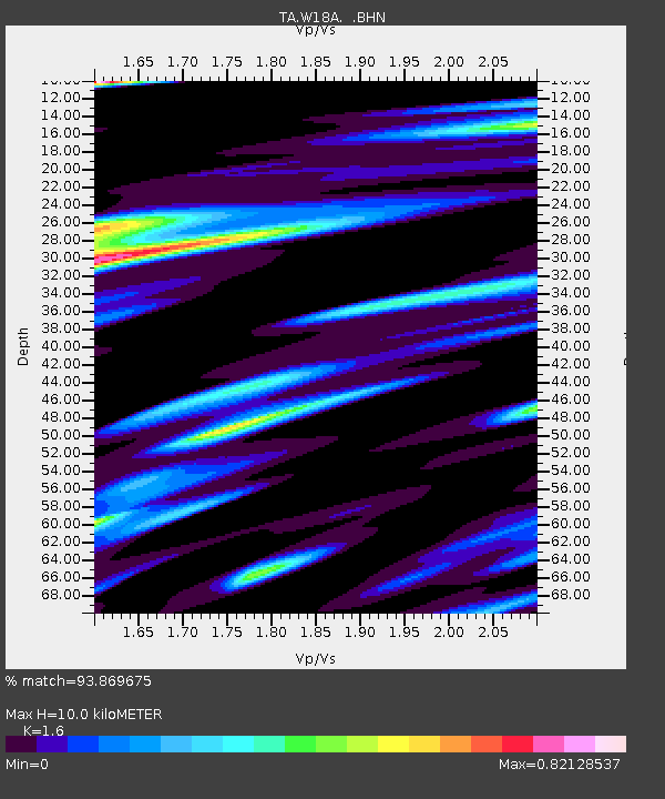
W18A Petrified Forest, AZ, USA - Earthquake Result Viewer
| Earthquake location: |
Peru-Brazil Border Region |
| Earthquake latitude/longitude: |
-7.9/-74.4 |
| Earthquake time(UTC): |
2007/07/12 (193) 05:23:49 GMT |
| Earthquake Depth: |
152 km |
| Earthquake Magnitude: |
5.9 MB, 6.1 MW, 6.0 MW |
| Earthquake Catalog/Contributor: |
WHDF/NEIC |
|
| Network: |
TA USArray Transportable Network (new EarthScope stations) |
| Station: |
W18A Petrified Forest, AZ, USA |
| Lat/Lon: |
35.12 N/109.74 W |
| Elevation: |
1750 m |
|
| Distance: |
54.3 deg |
| Az: |
324.249 deg |
| Baz: |
135.092 deg |
| Ray Param: |
0.06504582 |
| Estimated Moho Depth: |
10.0 km |
| Estimated Crust Vp/Vs: |
1.60 |
| Assumed Crust Vp: |
6.496 km/s |
| Estimated Crust Vs: |
4.06 km/s |
| Estimated Crust Poisson's Ratio: |
0.18 |
|
| Radial Match: |
93.869675 % |
| Radial Bump: |
261 |
| Transverse Match: |
75.796814 % |
| Transverse Bump: |
378 |
| SOD ConfigId: |
2564 |
| Insert Time: |
2010-03-06 10:21:34.435 +0000 |
| GWidth: |
2.5 |
| Max Bumps: |
400 |
| Tol: |
0.001 |
|

Signal To Noise
| Channel | StoN | STA | LTA |
| TA:W18A: :BHN:20070712T05:32:29.12302Z | 5.531603 | 3.3578505E-7 | 6.070303E-8 |
| TA:W18A: :BHE:20070712T05:32:29.12302Z | 4.9597116 | 3.0969767E-7 | 6.244267E-8 |
| TA:W18A: :BHZ:20070712T05:32:29.12302Z | 8.074773 | 6.2063424E-7 | 7.6860886E-8 |
| Arrivals |
| Ps | 1.0 SECOND |
| PpPs | 3.8 SECOND |
| PsPs/PpSs | 4.8 SECOND |


