You are here: Home > Network List > TA - USArray Transportable Network (new EarthScope stations) Stations List
> Station W18A Petrified Forest, AZ, USA > Earthquake Result Viewer
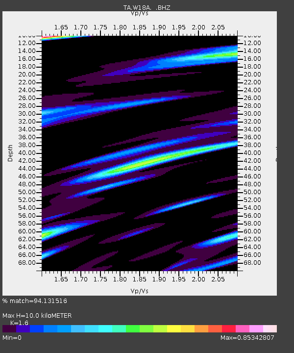
W18A Petrified Forest, AZ, USA - Earthquake Result Viewer
| Earthquake location: |
Panama |
| Earthquake latitude/longitude: |
9.6/-79.0 |
| Earthquake time(UTC): |
2009/07/04 (185) 06:49:35 GMT |
| Earthquake Depth: |
38 km |
| Earthquake Magnitude: |
6.0 MB, 5.5 MS, 6.0 MW, 6.0 MW |
| Earthquake Catalog/Contributor: |
WHDF/NEIC |
|
| Network: |
TA USArray Transportable Network (new EarthScope stations) |
| Station: |
W18A Petrified Forest, AZ, USA |
| Lat/Lon: |
35.12 N/109.74 W |
| Elevation: |
1750 m |
|
| Distance: |
37.9 deg |
| Az: |
316.902 deg |
| Baz: |
124.718 deg |
| Ray Param: |
0.07581024 |
| Estimated Moho Depth: |
10.0 km |
| Estimated Crust Vp/Vs: |
1.60 |
| Assumed Crust Vp: |
6.496 km/s |
| Estimated Crust Vs: |
4.06 km/s |
| Estimated Crust Poisson's Ratio: |
0.18 |
|
| Radial Match: |
94.131516 % |
| Radial Bump: |
216 |
| Transverse Match: |
75.39332 % |
| Transverse Bump: |
395 |
| SOD ConfigId: |
2648 |
| Insert Time: |
2010-03-06 10:22:06.905 +0000 |
| GWidth: |
2.5 |
| Max Bumps: |
400 |
| Tol: |
0.001 |
|

Signal To Noise
| Channel | StoN | STA | LTA |
| TA:W18A: :BHZ:20090704T06:56:18.348989Z | 28.085537 | 1.8065407E-6 | 6.432281E-8 |
| TA:W18A: :BHN:20090704T06:56:18.348989Z | 16.902916 | 8.0891044E-7 | 4.785627E-8 |
| TA:W18A: :BHE:20090704T06:56:18.348989Z | 17.310009 | 1.1493943E-6 | 6.640056E-8 |
| Arrivals |
| Ps | 1.0 SECOND |
| PpPs | 3.7 SECOND |
| PsPs/PpSs | 4.7 SECOND |


