You are here: Home > Network List > TA - USArray Transportable Network (new EarthScope stations) Stations List
> Station E20K Nigu River, AK, USA > Earthquake Result Viewer
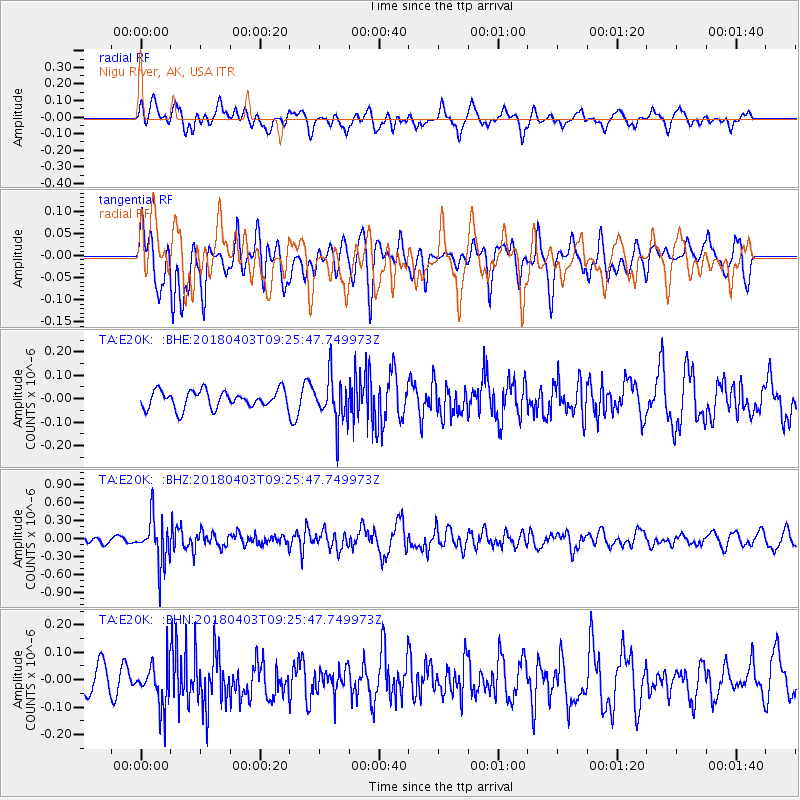
E20K Nigu River, AK, USA - Earthquake Result Viewer
*The percent match for this event was below the threshold and hence no stack was calculated.
| Earthquake location: |
North Of Halmahera, Indonesia |
| Earthquake latitude/longitude: |
3.0/128.0 |
| Earthquake time(UTC): |
2018/04/03 (093) 09:14:06 GMT |
| Earthquake Depth: |
72 km |
| Earthquake Magnitude: |
5.4 Mww |
| Earthquake Catalog/Contributor: |
NEIC PDE/us |
|
| Network: |
TA USArray Transportable Network (new EarthScope stations) |
| Station: |
E20K Nigu River, AK, USA |
| Lat/Lon: |
68.26 N/156.19 W |
| Elevation: |
866 m |
|
| Distance: |
82.0 deg |
| Az: |
21.394 deg |
| Baz: |
257.875 deg |
| Ray Param: |
$rayparam |
*The percent match for this event was below the threshold and hence was not used in the summary stack. |
|
| Radial Match: |
54.213634 % |
| Radial Bump: |
400 |
| Transverse Match: |
53.623894 % |
| Transverse Bump: |
400 |
| SOD ConfigId: |
13570011 |
| Insert Time: |
2019-04-30 01:48:09.979 +0000 |
| GWidth: |
2.5 |
| Max Bumps: |
400 |
| Tol: |
0.001 |
|
Signal To Noise
| Channel | StoN | STA | LTA |
| TA:E20K: :BHZ:20180403T09:25:47.749973Z | 5.910619 | 3.8288016E-7 | 6.4778355E-8 |
| TA:E20K: :BHN:20180403T09:25:47.749973Z | 1.3028147 | 7.950367E-8 | 6.102454E-8 |
| TA:E20K: :BHE:20180403T09:25:47.749973Z | 2.651788 | 9.897701E-8 | 3.7324636E-8 |
| Arrivals |
| Ps | |
| PpPs | |
| PsPs/PpSs | |


