You are here: Home > Network List > AV - Alaska Volcano Observatory Stations List
> Station SPNN North Nagishlamina, Mount Spurr, Alaska > Earthquake Result Viewer
SPNN North Nagishlamina, Mount Spurr, Alaska - Earthquake Result Viewer
| Earthquake location: |
Mindanao, Philippines |
| Earthquake latitude/longitude: |
6.8/126.8 |
| Earthquake time(UTC): |
2018/04/05 (095) 03:53:41 GMT |
| Earthquake Depth: |
64 km |
| Earthquake Magnitude: |
5.9 Mww |
| Earthquake Catalog/Contributor: |
NEIC PDE/us |
|
| Network: |
AV Alaska Volcano Observatory |
| Station: |
SPNN North Nagishlamina, Mount Spurr, Alaska |
| Lat/Lon: |
61.37 N/152.70 W |
| Elevation: |
1666 m |
|
| Distance: |
79.5 deg |
| Az: |
28.894 deg |
| Baz: |
264.949 deg |
| Ray Param: |
0.04878431 |
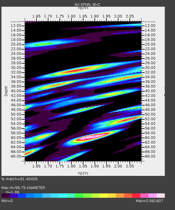
| Estimated Moho Depth: |
59.75 km |
| Estimated Crust Vp/Vs: |
1.86 |
| Assumed Crust Vp: |
6.566 km/s |
| Estimated Crust Vs: |
3.53 km/s |
| Estimated Crust Poisson's Ratio: |
0.30 |
|
| Radial Match: |
81.40405 % |
| Radial Bump: |
400 |
| Transverse Match: |
73.503716 % |
| Transverse Bump: |
400 |
| SOD ConfigId: |
13570011 |
| Insert Time: |
2019-04-30 01:51:34.068 +0000 |
| GWidth: |
2.5 |
| Max Bumps: |
400 |
| Tol: |
0.001 |
|

Signal To Noise
| Channel | StoN | STA | LTA |
| AV:SPNN: :BHZ:20180405T04:05:10.479973Z | 3.7159424 | 7.273263E-7 | 1.9573132E-7 |
| AV:SPNN: :BHN:20180405T04:05:10.479973Z | 1.8402553 | 3.814666E-7 | 2.0729006E-7 |
| AV:SPNN: :BHE:20180405T04:05:10.479973Z | 3.0220528 | 4.3194572E-7 | 1.4293124E-7 |
| Arrivals |
| Ps | 8.1 SECOND |
| PpPs | 25 SECOND |
| PsPs/PpSs | 33 SECOND |


