You are here: Home > Network List > TA - USArray Transportable Network (new EarthScope stations) Stations List
> Station F17K Baldwin Penninsula, AK, USA > Earthquake Result Viewer
F17K Baldwin Penninsula, AK, USA - Earthquake Result Viewer
| Earthquake location: |
Mindanao, Philippines |
| Earthquake latitude/longitude: |
6.8/126.8 |
| Earthquake time(UTC): |
2018/04/05 (095) 03:53:41 GMT |
| Earthquake Depth: |
64 km |
| Earthquake Magnitude: |
5.9 Mww |
| Earthquake Catalog/Contributor: |
NEIC PDE/us |
|
| Network: |
TA USArray Transportable Network (new EarthScope stations) |
| Station: |
F17K Baldwin Penninsula, AK, USA |
| Lat/Lon: |
66.44 N/161.25 W |
| Elevation: |
51 m |
|
| Distance: |
76.6 deg |
| Az: |
23.133 deg |
| Baz: |
256.078 deg |
| Ray Param: |
0.050743006 |
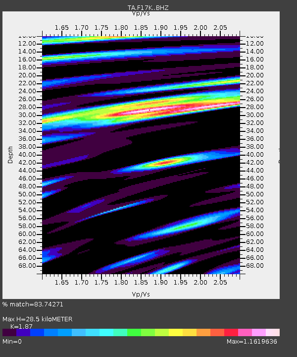
| Estimated Moho Depth: |
28.5 km |
| Estimated Crust Vp/Vs: |
1.87 |
| Assumed Crust Vp: |
6.276 km/s |
| Estimated Crust Vs: |
3.356 km/s |
| Estimated Crust Poisson's Ratio: |
0.30 |
|
| Radial Match: |
83.74271 % |
| Radial Bump: |
393 |
| Transverse Match: |
64.564285 % |
| Transverse Bump: |
400 |
| SOD ConfigId: |
13570011 |
| Insert Time: |
2019-04-30 01:54:01.388 +0000 |
| GWidth: |
2.5 |
| Max Bumps: |
400 |
| Tol: |
0.001 |
|

Signal To Noise
| Channel | StoN | STA | LTA |
| TA:F17K: :BHZ:20180405T04:04:54.499993Z | 9.789057 | 8.3929893E-7 | 8.5738485E-8 |
| TA:F17K: :BHN:20180405T04:04:54.499993Z | 1.4118725 | 1.7261623E-7 | 1.2226049E-7 |
| TA:F17K: :BHE:20180405T04:04:54.499993Z | 2.291638 | 2.0362351E-7 | 8.885502E-8 |
| Arrivals |
| Ps | 4.1 SECOND |
| PpPs | 13 SECOND |
| PsPs/PpSs | 17 SECOND |


