You are here: Home > Network List > TA - USArray Transportable Network (new EarthScope stations) Stations List
> Station H17K Granite Mountain, AK, USA > Earthquake Result Viewer
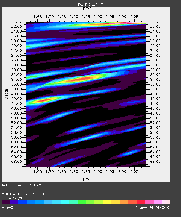
H17K Granite Mountain, AK, USA - Earthquake Result Viewer
| Earthquake location: |
Mindanao, Philippines |
| Earthquake latitude/longitude: |
6.8/126.8 |
| Earthquake time(UTC): |
2018/04/05 (095) 03:53:41 GMT |
| Earthquake Depth: |
64 km |
| Earthquake Magnitude: |
5.9 Mww |
| Earthquake Catalog/Contributor: |
NEIC PDE/us |
|
| Network: |
TA USArray Transportable Network (new EarthScope stations) |
| Station: |
H17K Granite Mountain, AK, USA |
| Lat/Lon: |
64.94 N/159.91 W |
| Elevation: |
396 m |
|
| Distance: |
76.8 deg |
| Az: |
24.775 deg |
| Baz: |
257.673 deg |
| Ray Param: |
0.0506119 |
| Estimated Moho Depth: |
10.0 km |
| Estimated Crust Vp/Vs: |
2.07 |
| Assumed Crust Vp: |
6.1 km/s |
| Estimated Crust Vs: |
2.943 km/s |
| Estimated Crust Poisson's Ratio: |
0.35 |
|
| Radial Match: |
83.351875 % |
| Radial Bump: |
400 |
| Transverse Match: |
66.76692 % |
| Transverse Bump: |
400 |
| SOD ConfigId: |
13570011 |
| Insert Time: |
2019-04-30 01:54:24.057 +0000 |
| GWidth: |
2.5 |
| Max Bumps: |
400 |
| Tol: |
0.001 |
|

Signal To Noise
| Channel | StoN | STA | LTA |
| TA:H17K: :BHZ:20180405T04:04:55.600029Z | 8.517684 | 7.7740367E-7 | 9.126937E-8 |
| TA:H17K: :BHN:20180405T04:04:55.600029Z | 1.3002198 | 8.301216E-8 | 6.3844716E-8 |
| TA:H17K: :BHE:20180405T04:04:55.600029Z | 4.076604 | 2.4247953E-7 | 5.948077E-8 |
| Arrivals |
| Ps | 1.8 SECOND |
| PpPs | 4.9 SECOND |
| PsPs/PpSs | 6.7 SECOND |


