You are here: Home > Network List > TA - USArray Transportable Network (new EarthScope stations) Stations List
> Station I17K Unalakleet, AK, USA > Earthquake Result Viewer
I17K Unalakleet, AK, USA - Earthquake Result Viewer
| Earthquake location: |
Mindanao, Philippines |
| Earthquake latitude/longitude: |
6.8/126.8 |
| Earthquake time(UTC): |
2018/04/05 (095) 03:53:41 GMT |
| Earthquake Depth: |
64 km |
| Earthquake Magnitude: |
5.9 Mww |
| Earthquake Catalog/Contributor: |
NEIC PDE/us |
|
| Network: |
TA USArray Transportable Network (new EarthScope stations) |
| Station: |
I17K Unalakleet, AK, USA |
| Lat/Lon: |
63.89 N/160.70 W |
| Elevation: |
105 m |
|
| Distance: |
76.3 deg |
| Az: |
25.758 deg |
| Baz: |
257.197 deg |
| Ray Param: |
0.050987516 |
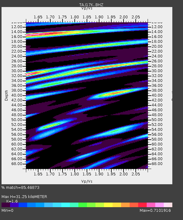
| Estimated Moho Depth: |
31.25 km |
| Estimated Crust Vp/Vs: |
1.60 |
| Assumed Crust Vp: |
6.276 km/s |
| Estimated Crust Vs: |
3.922 km/s |
| Estimated Crust Poisson's Ratio: |
0.18 |
|
| Radial Match: |
85.46873 % |
| Radial Bump: |
400 |
| Transverse Match: |
66.82641 % |
| Transverse Bump: |
400 |
| SOD ConfigId: |
13570011 |
| Insert Time: |
2019-04-30 01:54:35.106 +0000 |
| GWidth: |
2.5 |
| Max Bumps: |
400 |
| Tol: |
0.001 |
|
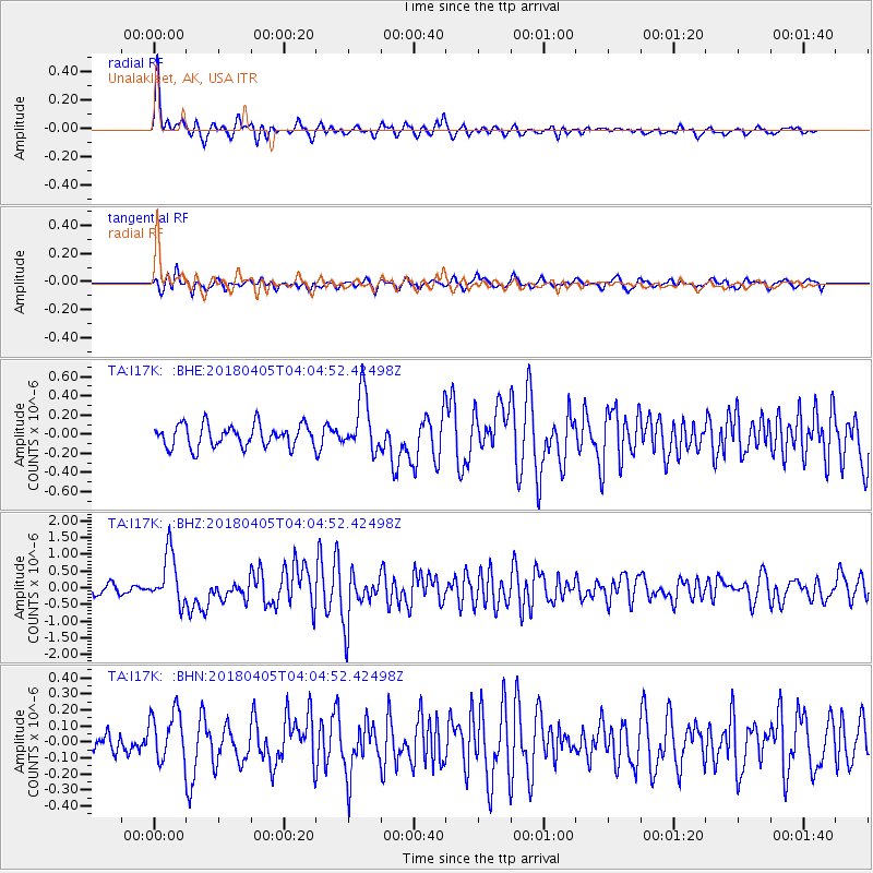
Signal To Noise
| Channel | StoN | STA | LTA |
| TA:I17K: :BHZ:20180405T04:04:52.42498Z | 6.1117926 | 7.6447867E-7 | 1.2508256E-7 |
| TA:I17K: :BHN:20180405T04:04:52.42498Z | 2.1583827 | 1.572941E-7 | 7.2875906E-8 |
| TA:I17K: :BHE:20180405T04:04:52.42498Z | 2.5451972 | 2.9739266E-7 | 1.1684464E-7 |
| Arrivals |
| Ps | 3.1 SECOND |
| PpPs | 13 SECOND |
| PsPs/PpSs | 16 SECOND |


