You are here: Home > Network List > CN - Canadian National Seismograph Network Stations List
> Station INK INUVIK, NT > Earthquake Result Viewer
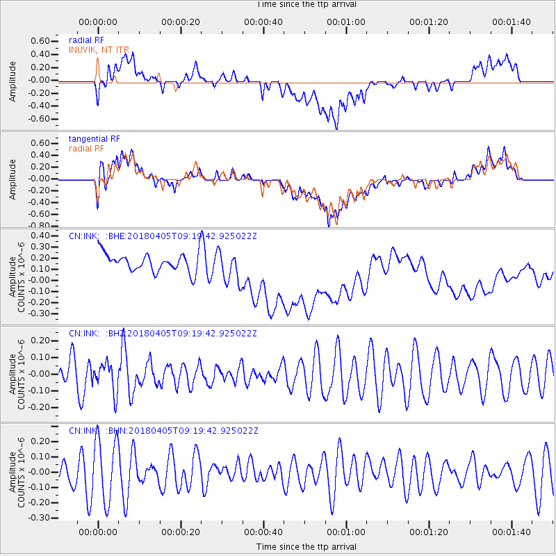
INK INUVIK, NT - Earthquake Result Viewer
*The percent match for this event was below the threshold and hence no stack was calculated.
| Earthquake location: |
Fiji Islands Region |
| Earthquake latitude/longitude: |
-18.3/-177.9 |
| Earthquake time(UTC): |
2018/04/05 (095) 09:07:59 GMT |
| Earthquake Depth: |
507 km |
| Earthquake Magnitude: |
5.8 Mww |
| Earthquake Catalog/Contributor: |
NEIC PDE/us |
|
| Network: |
CN Canadian National Seismograph Network |
| Station: |
INK INUVIK, NT |
| Lat/Lon: |
68.31 N/133.53 W |
| Elevation: |
44 m |
|
| Distance: |
92.2 deg |
| Az: |
15.08 deg |
| Baz: |
221.659 deg |
| Ray Param: |
$rayparam |
*The percent match for this event was below the threshold and hence was not used in the summary stack. |
|
| Radial Match: |
38.28298 % |
| Radial Bump: |
400 |
| Transverse Match: |
37.80459 % |
| Transverse Bump: |
400 |
| SOD ConfigId: |
13570011 |
| Insert Time: |
2019-04-30 01:58:52.280 +0000 |
| GWidth: |
2.5 |
| Max Bumps: |
400 |
| Tol: |
0.001 |
|
Signal To Noise
| Channel | StoN | STA | LTA |
| CN:INK: :BHZ:20180405T09:19:42.925022Z | 1.0697882 | 8.9870085E-8 | 8.400736E-8 |
| CN:INK: :BHN:20180405T09:19:42.925022Z | 3.2813814 | 2.1424859E-7 | 6.52922E-8 |
| CN:INK: :BHE:20180405T09:19:42.925022Z | 1.8002388 | 1.4731278E-7 | 8.182957E-8 |
| Arrivals |
| Ps | |
| PpPs | |
| PsPs/PpSs | |


