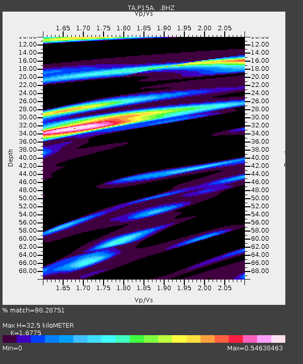
P15A Leamington, UT, USA - Earthquake Result Viewer
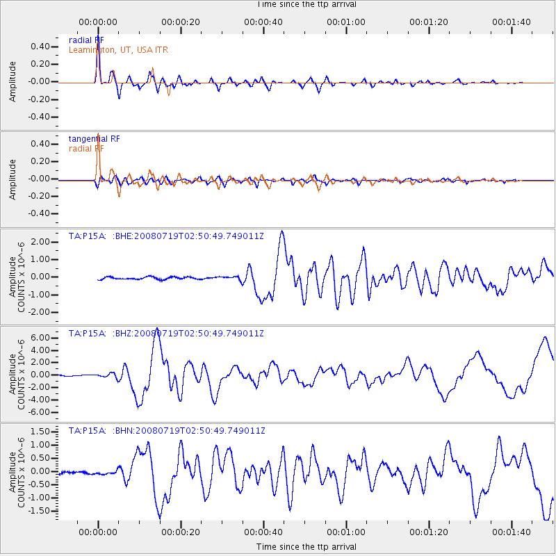
Earthquake location: Off East Coast Of Honshu, Japan
Earthquake latitude/longitude: 37.6/142.2
Earthquake time(UTC): 2008/07/19 (201) 02:39:28 GMT
Earthquake Depth: 22 km
Earthquake Magnitude: 6.2 MB, 7.0 MS, 7.0 MW, 6.9 MW
Earthquake Catalog/Contributor: WHDF/NEIC
Network: TA USArray Transportable Network (new EarthScope stations)
Station: P15A Leamington, UT, USA
Lat/Lon: 39.57 N/112.28 W
Elevation: 1576 m
Distance: 77.2 deg
Az: 49.787 deg
Baz: 308.258 deg
Ray Param: 0.050432347
Estimated Moho Depth: 32.5 km
Estimated Crust Vp/Vs: 1.68
Assumed Crust Vp: 6.276 km/s
Estimated Crust Vs: 3.741 km/s
Estimated Crust Poisson's Ratio: 0.22
Radial Match: 98.28751 %
Radial Bump: 400
Transverse Match: 91.12702 %
Transverse Bump: 400
SOD ConfigId: 2504
Insert Time: 2010-03-06 10:25:45.255 +0000
GWidth: 2.5
Max Bumps: 400
Tol: 0.001

Signal To Noise

ChannelStoNSTALTA
TA:P15A: :BHZ:20080719T02:50:49.749011Z4.12448643.6242025E-78.7870404E-8
TA:P15A: :BHN:20080719T02:50:49.749011Z1.50877126.217427E-84.120855E-8
TA:P15A: :BHE:20080719T02:50:49.749011Z1.60431311.0950604E-76.825727E-8
Arrivals
Ps3.6 SECOND
PpPs13 SECOND
PsPs/PpSs17 SECOND