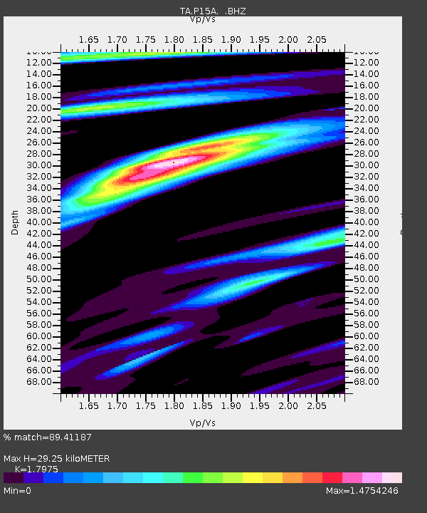
P15A Leamington, UT, USA - Earthquake Result Viewer

Earthquake location: Andreanof Islands, Aleutian Is.
Earthquake latitude/longitude: 52.2/-175.7
Earthquake time(UTC): 2008/08/07 (220) 18:30:03 GMT
Earthquake Depth: 12 km
Earthquake Magnitude: 5.6 MB, 5.5 MS, 5.8 MW, 5.8 MW
Earthquake Catalog/Contributor: WHDF/NEIC
Network: TA USArray Transportable Network (new EarthScope stations)
Station: P15A Leamington, UT, USA
Lat/Lon: 39.57 N/112.28 W
Elevation: 1576 m
Distance: 44.5 deg
Az: 80.341 deg
Baz: 308.263 deg
Ray Param: 0.07187416
Estimated Moho Depth: 29.25 km
Estimated Crust Vp/Vs: 1.80
Assumed Crust Vp: 6.276 km/s
Estimated Crust Vs: 3.491 km/s
Estimated Crust Poisson's Ratio: 0.28
Radial Match: 89.41187 %
Radial Bump: 400
Transverse Match: 77.28665 %
Transverse Bump: 400
SOD ConfigId: 2504
Insert Time: 2010-03-06 10:25:51.431 +0000
GWidth: 2.5
Max Bumps: 400
Tol: 0.001

Signal To Noise

ChannelStoNSTALTA
TA:P15A: :BHZ:20080807T18:37:43.325005Z4.6883082.6649073E-75.6841564E-8
TA:P15A: :BHN:20080807T18:37:43.325005Z1.54123081.0174729E-76.601691E-8
TA:P15A: :BHE:20080807T18:37:43.325005Z2.010661.2988502E-76.459821E-8
Arrivals
Ps3.9 SECOND
PpPs12 SECOND
PsPs/PpSs16 SECOND