You are here: Home > Network List > TA - USArray Transportable Network (new EarthScope stations) Stations List
> Station P15A Leamington, UT, USA > Earthquake Result Viewer
P15A Leamington, UT, USA - Earthquake Result Viewer
| Earthquake location: |
Windward Islands |
| Earthquake latitude/longitude: |
15.0/-61.3 |
| Earthquake time(UTC): |
2007/11/29 (333) 19:00:19 GMT |
| Earthquake Depth: |
148 km |
| Earthquake Magnitude: |
6.9 MB, 7.4 MW, 7.4 MW |
| Earthquake Catalog/Contributor: |
WHDF/NEIC |
|
| Network: |
TA USArray Transportable Network (new EarthScope stations) |
| Station: |
P15A Leamington, UT, USA |
| Lat/Lon: |
39.57 N/112.28 W |
| Elevation: |
1576 m |
|
| Distance: |
50.7 deg |
| Az: |
309.106 deg |
| Baz: |
104.001 deg |
| Ray Param: |
0.06736202 |
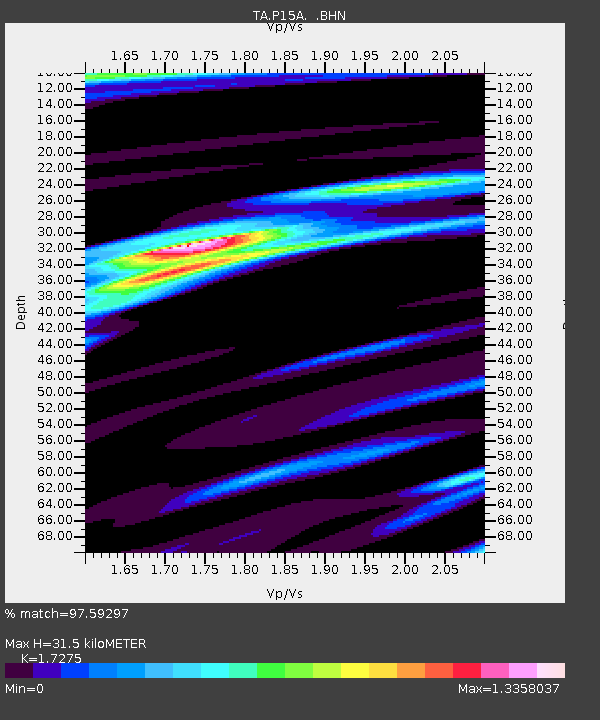
| Estimated Moho Depth: |
31.5 km |
| Estimated Crust Vp/Vs: |
1.73 |
| Assumed Crust Vp: |
6.276 km/s |
| Estimated Crust Vs: |
3.633 km/s |
| Estimated Crust Poisson's Ratio: |
0.25 |
|
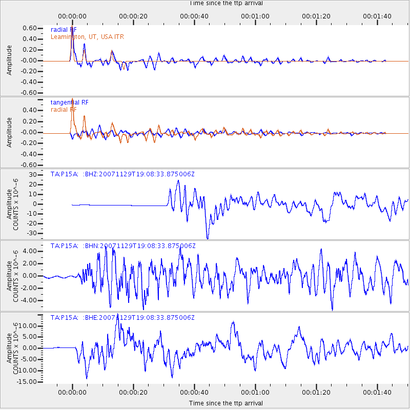
| Radial Match: |
97.59297 % |
| Radial Bump: |
347 |
| Transverse Match: |
93.62406 % |
| Transverse Bump: |
400 |
| SOD ConfigId: |
2564 |
| Insert Time: |
2010-03-06 10:26:30.433 +0000 |
| GWidth: |
2.5 |
| Max Bumps: |
400 |
| Tol: |
0.001 |
|
Signal To Noise
| Channel | StoN | STA | LTA |
| TA:P15A: :BHN:20071129T19:08:33.875006Z | 4.258122 | 4.8501863E-7 | 1.13904356E-7 |
| TA:P15A: :BHE:20071129T19:08:33.875006Z | 30.098497 | 4.6585924E-6 | 1.5477823E-7 |
| TA:P15A: :BHZ:20071129T19:08:33.875006Z | 35.442307 | 1.029968E-5 | 2.906041E-7 |
| Arrivals |
| Ps | 3.9 SECOND |
| PpPs | 13 SECOND |
| PsPs/PpSs | 17 SECOND |


