You are here: Home > Network List > TA - USArray Transportable Network (new EarthScope stations) Stations List
> Station P15A Leamington, UT, USA > Earthquake Result Viewer
P15A Leamington, UT, USA - Earthquake Result Viewer
| Earthquake location: |
Northern Chile |
| Earthquake latitude/longitude: |
-22.2/-69.9 |
| Earthquake time(UTC): |
2007/11/14 (318) 15:40:50 GMT |
| Earthquake Depth: |
40 km |
| Earthquake Magnitude: |
6.7 MB, 7.4 MS, 7.7 MW, 7.4 ME |
| Earthquake Catalog/Contributor: |
WHDF/NEIC |
|
| Network: |
TA USArray Transportable Network (new EarthScope stations) |
| Station: |
P15A Leamington, UT, USA |
| Lat/Lon: |
39.57 N/112.28 W |
| Elevation: |
1576 m |
|
| Distance: |
73.1 deg |
| Az: |
327.011 deg |
| Baz: |
139.26 deg |
| Ray Param: |
0.053134598 |
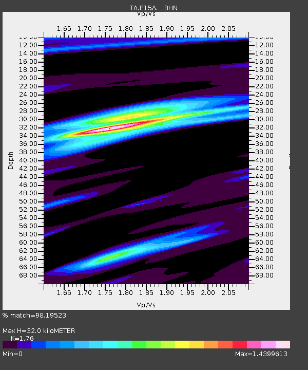
| Estimated Moho Depth: |
32.0 km |
| Estimated Crust Vp/Vs: |
1.76 |
| Assumed Crust Vp: |
6.276 km/s |
| Estimated Crust Vs: |
3.566 km/s |
| Estimated Crust Poisson's Ratio: |
0.26 |
|
| Radial Match: |
98.19523 % |
| Radial Bump: |
387 |
| Transverse Match: |
95.13857 % |
| Transverse Bump: |
400 |
| SOD ConfigId: |
2564 |
| Insert Time: |
2010-03-06 10:26:35.281 +0000 |
| GWidth: |
2.5 |
| Max Bumps: |
400 |
| Tol: |
0.001 |
|
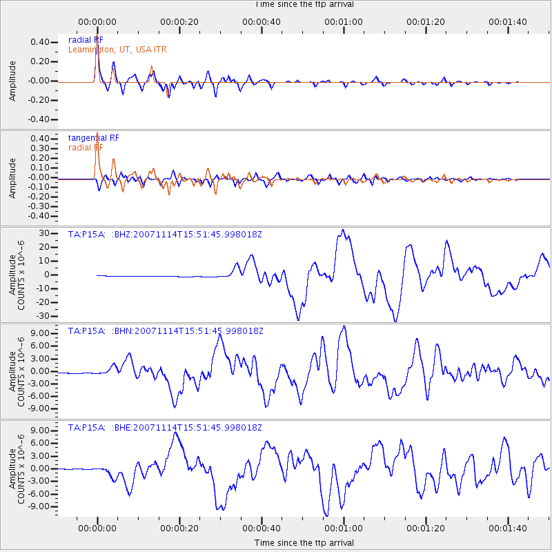
Signal To Noise
| Channel | StoN | STA | LTA |
| TA:P15A: :BHN:20071114T15:51:45.998018Z | 7.5942044 | 9.737765E-7 | 1.2822628E-7 |
| TA:P15A: :BHE:20071114T15:51:45.998018Z | 12.50225 | 1.3205029E-6 | 1.0562122E-7 |
| TA:P15A: :BHZ:20071114T15:51:45.998018Z | 21.452158 | 4.165252E-6 | 1.9416471E-7 |
| Arrivals |
| Ps | 4.0 SECOND |
| PpPs | 14 SECOND |
| PsPs/PpSs | 18 SECOND |


