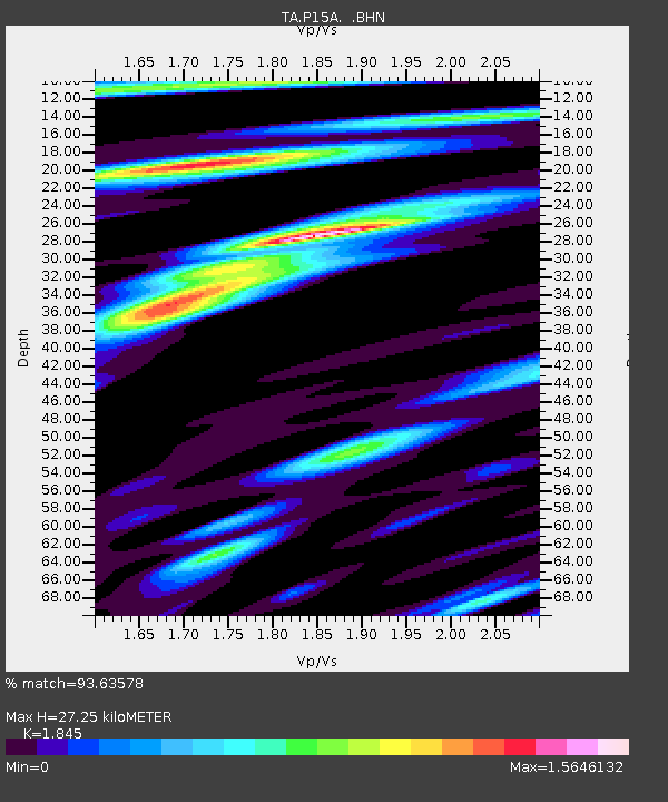
P15A Leamington, UT, USA - Earthquake Result Viewer
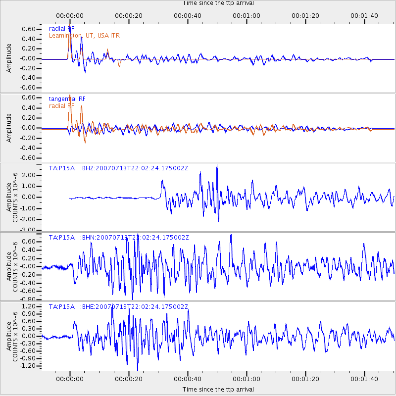
Earthquake location: Andreanof Islands, Aleutian Is.
Earthquake latitude/longitude: 51.8/-176.3
Earthquake time(UTC): 2007/07/13 (194) 21:54:43 GMT
Earthquake Depth: 35 km
Earthquake Magnitude: 5.7 MB, 5.6 MS, 6.0 MW, 5.9 MW
Earthquake Catalog/Contributor: WHDF/NEIC
Network: TA USArray Transportable Network (new EarthScope stations)
Station: P15A Leamington, UT, USA
Lat/Lon: 39.57 N/112.28 W
Elevation: 1576 m
Distance: 44.9 deg
Az: 79.564 deg
Baz: 307.866 deg
Ray Param: 0.07153051
Estimated Moho Depth: 27.25 km
Estimated Crust Vp/Vs: 1.85
Assumed Crust Vp: 6.276 km/s
Estimated Crust Vs: 3.402 km/s
Estimated Crust Poisson's Ratio: 0.29
Radial Match: 93.63578 %
Radial Bump: 400
Transverse Match: 89.268364 %
Transverse Bump: 400
SOD ConfigId: 2564
Insert Time: 2010-03-06 10:27:08.706 +0000
GWidth: 2.5
Max Bumps: 400
Tol: 0.001

Signal To Noise

ChannelStoNSTALTA
TA:P15A: :BHN:20070713T22:02:24.175002Z6.9527582.1187593E-73.0473654E-8
TA:P15A: :BHE:20070713T22:02:24.175002Z10.5712623.1273362E-72.9583378E-8
TA:P15A: :BHZ:20070713T22:02:24.175002Z18.4051887.34243E-73.9893266E-8
Arrivals
Ps3.9 SECOND
PpPs12 SECOND
PsPs/PpSs16 SECOND