You are here: Home > Network List > CI - Caltech Regional Seismic Network Stations List
> Station JCS Julian Camp Stevens, California, USA > Earthquake Result Viewer
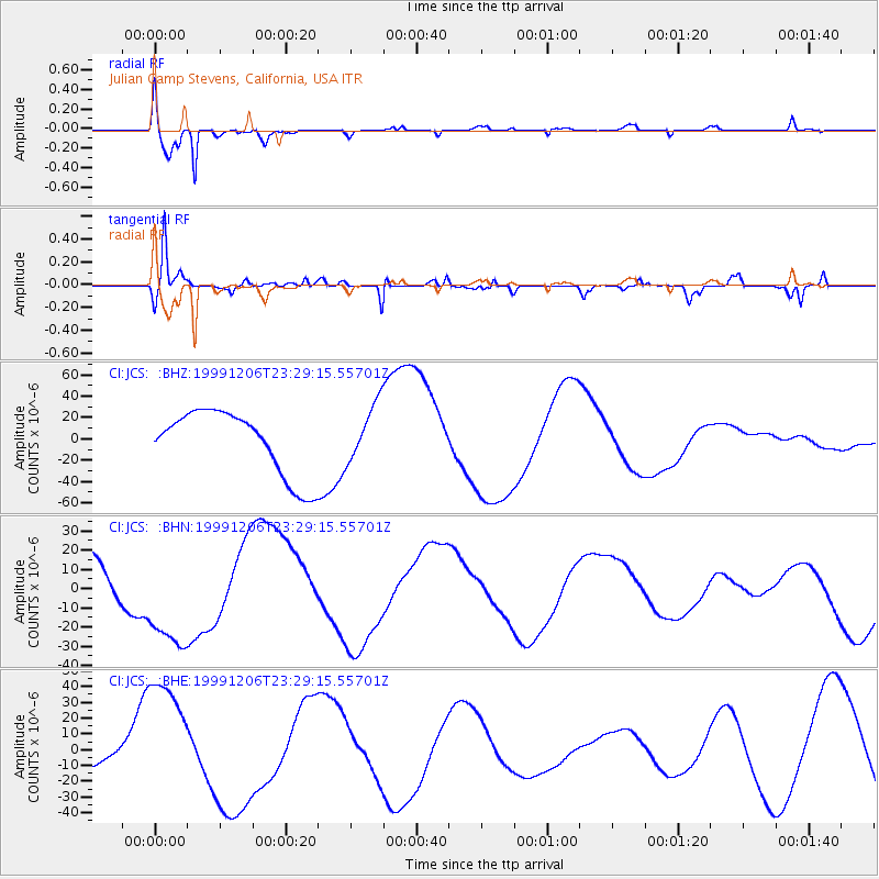
JCS Julian Camp Stevens, California, USA - Earthquake Result Viewer

| Earthquake location: |
Kodiak Island Region, Alaska |
| Earthquake latitude/longitude: |
57.4/-154.4 |
| Earthquake time(UTC): |
1999/12/06 (340) 23:22:55 GMT |
| Earthquake Depth: |
50 km |
| Earthquake Magnitude: |
5.6 MB, 5.5 ML, 5.4 ML |
| Earthquake Catalog/Contributor: |
WHDF/NEIC |
|
| Network: |
CI Caltech Regional Seismic Network |
| Station: |
JCS Julian Camp Stevens, California, USA |
| Lat/Lon: |
33.09 N/116.60 W |
| Elevation: |
1258 m |
|
| Distance: |
35.3 deg |
| Az: |
117.075 deg |
| Baz: |
324.919 deg |
| Ray Param: |
0.07716935 |
| Estimated Moho Depth: |
12.75 km |
| Estimated Crust Vp/Vs: |
1.61 |
| Assumed Crust Vp: |
6.264 km/s |
| Estimated Crust Vs: |
3.89 km/s |
| Estimated Crust Poisson's Ratio: |
0.19 |
|
| Radial Match: |
93.94446 % |
| Radial Bump: |
331 |
| Transverse Match: |
82.24331 % |
| Transverse Bump: |
269 |
| SOD ConfigId: |
3770 |
| Insert Time: |
2010-02-26 01:54:43.554 +0000 |
| GWidth: |
2.5 |
| Max Bumps: |
400 |
| Tol: |
0.001 |
|
Signal To Noise
| Channel | StoN | STA | LTA |
| CI:JCS: :BHN:19991206T23:29:15.55701Z | 2.107305 | 3.0241736E-5 | 1.4350906E-5 |
| CI:JCS: :BHE:19991206T23:29:15.55701Z | 4.564658 | 4.1127183E-5 | 9.009916E-6 |
| CI:JCS: :BHZ:19991206T23:29:15.55701Z | 0.89079213 | 2.7055125E-5 | 3.0371984E-5 |
| Arrivals |
| Ps | 1.3 SECOND |
| PpPs | 4.9 SECOND |
| PsPs/PpSs | 6.3 SECOND |


