You are here: Home > Network List > CN - Canadian National Seismograph Network Stations List
> Station INK INUVIK, NT > Earthquake Result Viewer
INK INUVIK, NT - Earthquake Result Viewer
*The percent match for this event was below the threshold and hence no stack was calculated.
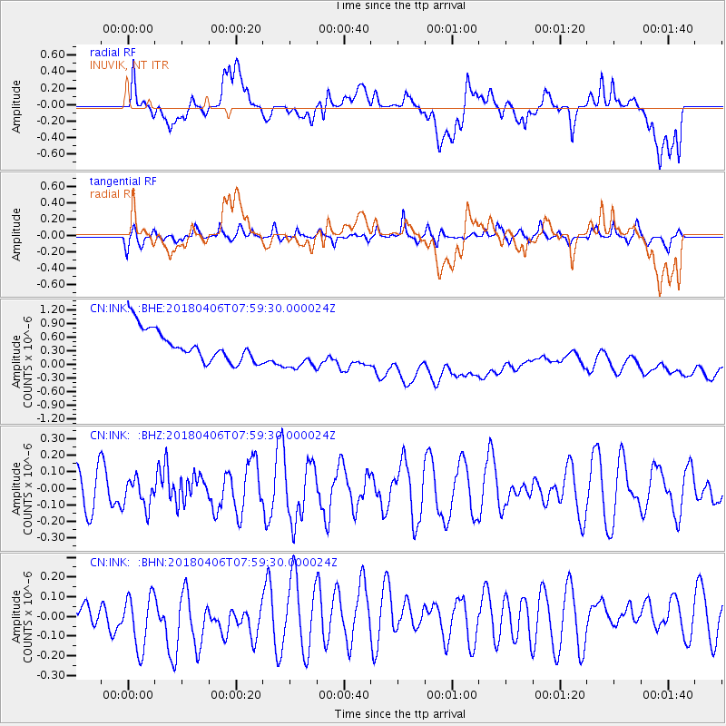
| Earthquake location: |
Near North Coast Of Irian Jaya |
| Earthquake latitude/longitude: |
-1.5/138.2 |
| Earthquake time(UTC): |
2018/04/06 (096) 07:46:58 GMT |
| Earthquake Depth: |
10 km |
| Earthquake Magnitude: |
5.5 Mww |
| Earthquake Catalog/Contributor: |
NEIC PDE/us |
|
| Network: |
CN Canadian National Seismograph Network |
| Station: |
INK INUVIK, NT |
| Lat/Lon: |
68.31 N/133.53 W |
| Elevation: |
44 m |
|
| Distance: |
90.7 deg |
| Az: |
21.818 deg |
| Baz: |
267.879 deg |
| Ray Param: |
$rayparam |
*The percent match for this event was below the threshold and hence was not used in the summary stack. |
|
| Radial Match: |
12.98699 % |
| Radial Bump: |
400 |
| Transverse Match: |
54.494774 % |
| Transverse Bump: |
400 |
| SOD ConfigId: |
13570011 |
| Insert Time: |
2019-04-30 02:12:27.747 +0000 |
| GWidth: |
2.5 |
| Max Bumps: |
400 |
| Tol: |
0.001 |
|
Signal To Noise
| Channel | StoN | STA | LTA |
| CN:INK: :BHZ:20180406T07:59:30.000024Z | 0.6583572 | 8.6829274E-8 | 1.3188779E-7 |
| CN:INK: :BHN:20180406T07:59:30.000024Z | 2.2043498 | 1.5523779E-7 | 7.042339E-8 |
| CN:INK: :BHE:20180406T07:59:30.000024Z | 1.212564 | 4.194604E-7 | 3.459285E-7 |
| Arrivals |
| Ps | |
| PpPs | |
| PsPs/PpSs | |


