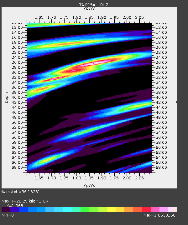
P15A Leamington, UT, USA - Earthquake Result Viewer
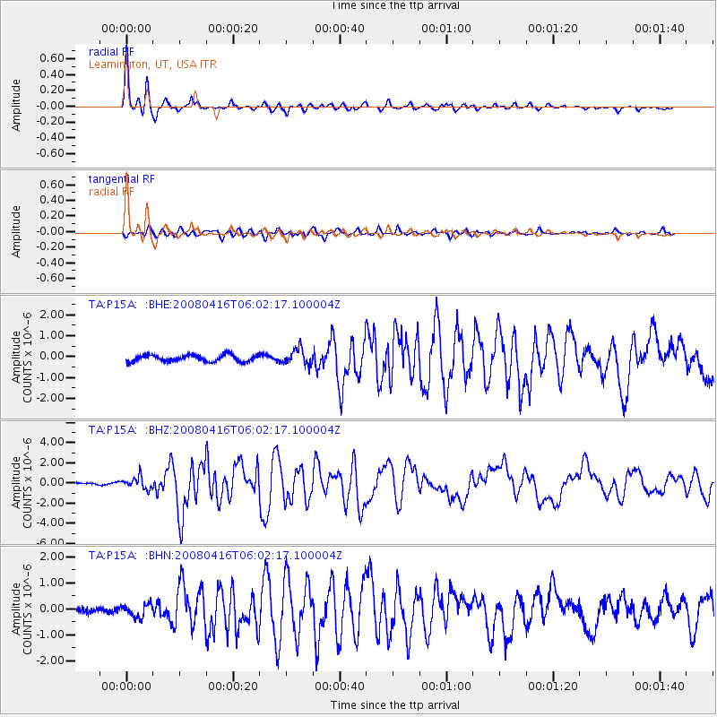
Earthquake location: Andreanof Islands, Aleutian Is.
Earthquake latitude/longitude: 51.9/-179.2
Earthquake time(UTC): 2008/04/16 (107) 05:54:19 GMT
Earthquake Depth: 13 km
Earthquake Magnitude: 6.1 MB, 6.5 MS, 6.6 MW, 6.6 MW
Earthquake Catalog/Contributor: WHDF/NEIC
Network: TA USArray Transportable Network (new EarthScope stations)
Station: P15A Leamington, UT, USA
Lat/Lon: 39.57 N/112.28 W
Elevation: 1576 m
Distance: 46.7 deg
Az: 77.682 deg
Baz: 308.413 deg
Ray Param: 0.07048075
Estimated Moho Depth: 26.25 km
Estimated Crust Vp/Vs: 1.87
Assumed Crust Vp: 6.276 km/s
Estimated Crust Vs: 3.365 km/s
Estimated Crust Poisson's Ratio: 0.30
Radial Match: 96.15361 %
Radial Bump: 346
Transverse Match: 82.81619 %
Transverse Bump: 400
SOD ConfigId: 2504
Insert Time: 2010-03-06 10:27:29.185 +0000
GWidth: 2.5
Max Bumps: 400
Tol: 0.001

Signal To Noise

ChannelStoNSTALTA
TA:P15A: :BHZ:20080416T06:02:17.100004Z4.18783335.9848486E-71.4291038E-7
TA:P15A: :BHN:20080416T06:02:17.100004Z3.3463152.4467045E-77.311638E-8
TA:P15A: :BHE:20080416T06:02:17.100004Z2.3409873.7118767E-71.5856034E-7
Arrivals
Ps3.8 SECOND
PpPs11 SECOND
PsPs/PpSs15 SECOND