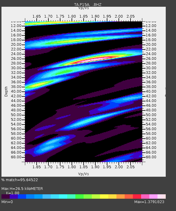
P15A Leamington, UT, USA - Earthquake Result Viewer
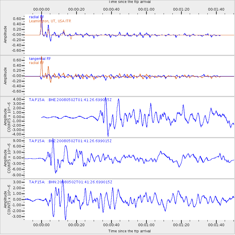
Earthquake location: Andreanof Islands, Aleutian Is.
Earthquake latitude/longitude: 51.9/-177.5
Earthquake time(UTC): 2008/05/02 (123) 01:33:37 GMT
Earthquake Depth: 14 km
Earthquake Magnitude: 6.3 MB, 6.8 MS, 6.6 MW, 6.6 MW
Earthquake Catalog/Contributor: WHDF/NEIC
Network: TA USArray Transportable Network (new EarthScope stations)
Station: P15A Leamington, UT, USA
Lat/Lon: 39.57 N/112.28 W
Elevation: 1576 m
Distance: 45.7 deg
Az: 78.754 deg
Baz: 308.107 deg
Ray Param: 0.07109554
Estimated Moho Depth: 26.5 km
Estimated Crust Vp/Vs: 1.88
Assumed Crust Vp: 6.276 km/s
Estimated Crust Vs: 3.338 km/s
Estimated Crust Poisson's Ratio: 0.30
Radial Match: 95.64522 %
Radial Bump: 316
Transverse Match: 86.80312 %
Transverse Bump: 400
SOD ConfigId: 2504
Insert Time: 2010-03-06 10:27:30.592 +0000
GWidth: 2.5
Max Bumps: 400
Tol: 0.001

Signal To Noise

ChannelStoNSTALTA
TA:P15A: :BHZ:20080502T01:41:26.699015Z12.4535381.304086E-61.0471611E-7
TA:P15A: :BHN:20080502T01:41:26.699015Z2.54362253.165165E-71.2443533E-7
TA:P15A: :BHE:20080502T01:41:26.699015Z4.49252656.5407886E-71.4559265E-7
Arrivals
Ps3.9 SECOND
PpPs11 SECOND
PsPs/PpSs15 SECOND