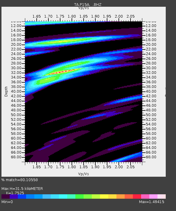
P15A Leamington, UT, USA - Earthquake Result Viewer
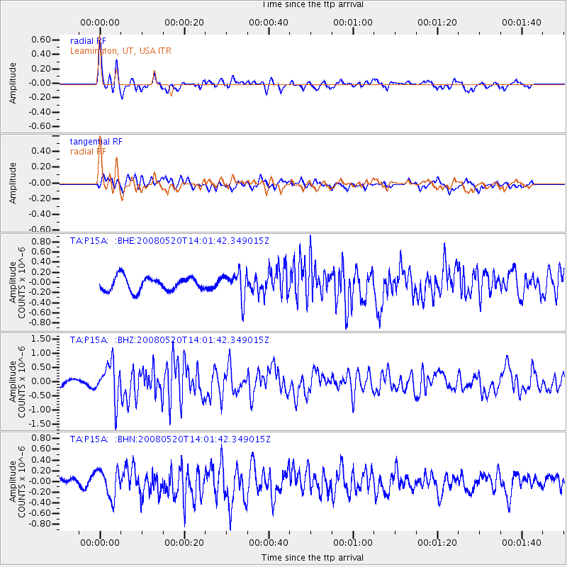
Earthquake location: Rat Islands, Aleutian Islands
Earthquake latitude/longitude: 51.2/178.8
Earthquake time(UTC): 2008/05/20 (141) 13:53:35 GMT
Earthquake Depth: 27 km
Earthquake Magnitude: 5.8 MB, 6.0 MS, 6.3 MW, 6.3 MW
Earthquake Catalog/Contributor: WHDF/NEIC
Network: TA USArray Transportable Network (new EarthScope stations)
Station: P15A Leamington, UT, USA
Lat/Lon: 39.57 N/112.28 W
Elevation: 1576 m
Distance: 48.1 deg
Az: 75.694 deg
Baz: 307.871 deg
Ray Param: 0.069519036
Estimated Moho Depth: 31.5 km
Estimated Crust Vp/Vs: 1.75
Assumed Crust Vp: 6.276 km/s
Estimated Crust Vs: 3.581 km/s
Estimated Crust Poisson's Ratio: 0.26
Radial Match: 80.10558 %
Radial Bump: 400
Transverse Match: 63.00274 %
Transverse Bump: 400
SOD ConfigId: 2504
Insert Time: 2010-03-06 10:27:36.024 +0000
GWidth: 2.5
Max Bumps: 400
Tol: 0.001

Signal To Noise

ChannelStoNSTALTA
TA:P15A: :BHZ:20080520T14:01:42.349015Z5.31768666.6207815E-71.2450492E-7
TA:P15A: :BHN:20080520T14:01:42.349015Z1.5386642.6031253E-71.6918088E-7
TA:P15A: :BHE:20080520T14:01:42.349015Z2.04340532.7056356E-71.3240818E-7
Arrivals
Ps4.0 SECOND
PpPs13 SECOND
PsPs/PpSs17 SECOND