You are here: Home > Network List > TA - USArray Transportable Network (new EarthScope stations) Stations List
> Station L15K Ungalak Mountain, AK, USA > Earthquake Result Viewer
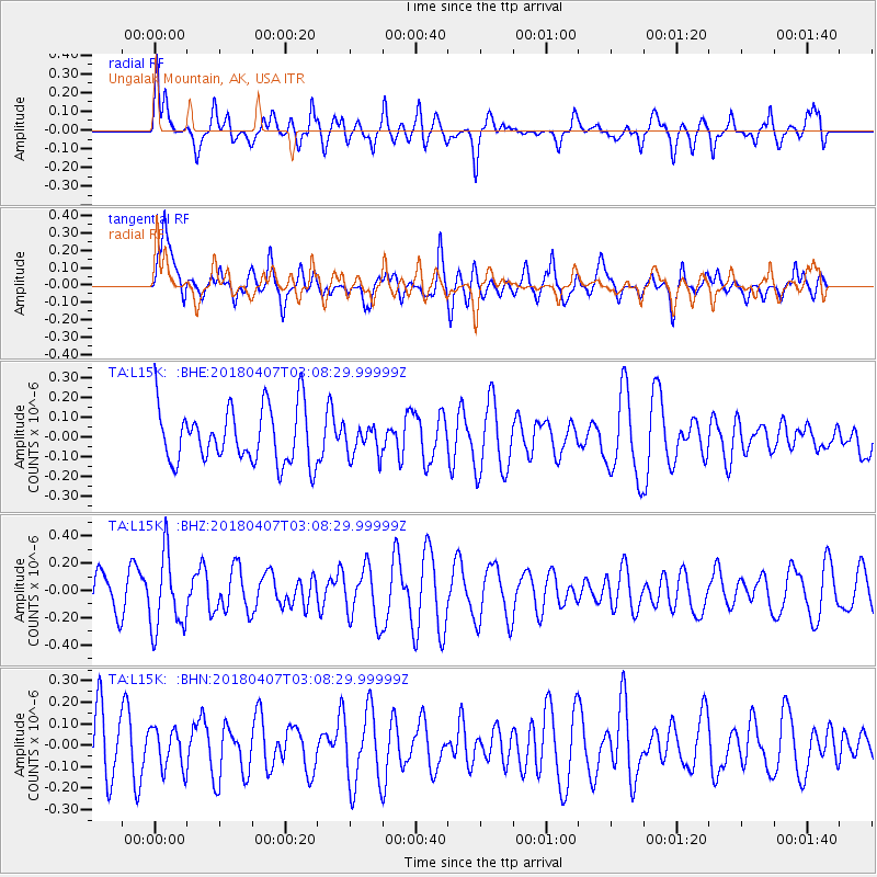
L15K Ungalak Mountain, AK, USA - Earthquake Result Viewer
*The percent match for this event was below the threshold and hence no stack was calculated.
| Earthquake location: |
New Guinea, Papua New Guinea |
| Earthquake latitude/longitude: |
-6.3/142.7 |
| Earthquake time(UTC): |
2018/04/07 (097) 02:56:50 GMT |
| Earthquake Depth: |
10 km |
| Earthquake Magnitude: |
5.3 Mww |
| Earthquake Catalog/Contributor: |
NEIC PDE/us |
|
| Network: |
TA USArray Transportable Network (new EarthScope stations) |
| Station: |
L15K Ungalak Mountain, AK, USA |
| Lat/Lon: |
61.68 N/161.49 W |
| Elevation: |
219 m |
|
| Distance: |
80.2 deg |
| Az: |
23.615 deg |
| Baz: |
236.615 deg |
| Ray Param: |
$rayparam |
*The percent match for this event was below the threshold and hence was not used in the summary stack. |
|
| Radial Match: |
63.003056 % |
| Radial Bump: |
400 |
| Transverse Match: |
51.277992 % |
| Transverse Bump: |
400 |
| SOD ConfigId: |
13570011 |
| Insert Time: |
2019-04-30 02:18:20.933 +0000 |
| GWidth: |
2.5 |
| Max Bumps: |
400 |
| Tol: |
0.001 |
|
Signal To Noise
| Channel | StoN | STA | LTA |
| TA:L15K: :BHZ:20180407T03:08:29.99999Z | 1.777009 | 2.7620263E-7 | 1.554312E-7 |
| TA:L15K: :BHN:20180407T03:08:29.99999Z | 0.6256752 | 9.545838E-8 | 1.5256859E-7 |
| TA:L15K: :BHE:20180407T03:08:29.99999Z | 0.54457605 | 7.561872E-8 | 1.3885796E-7 |
| Arrivals |
| Ps | |
| PpPs | |
| PsPs/PpSs | |


