You are here: Home > Network List > TA - USArray Transportable Network (new EarthScope stations) Stations List
> Station P15A Leamington, UT, USA > Earthquake Result Viewer
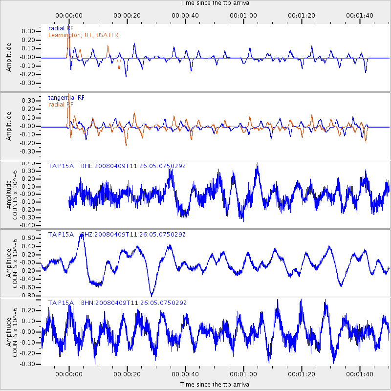
P15A Leamington, UT, USA - Earthquake Result Viewer
*The percent match for this event was below the threshold and hence no stack was calculated.
| Earthquake location: |
Loyalty Islands |
| Earthquake latitude/longitude: |
-20.2/168.9 |
| Earthquake time(UTC): |
2008/04/09 (100) 11:13:17 GMT |
| Earthquake Depth: |
13 km |
| Earthquake Magnitude: |
5.6 MB, 6.3 MS, 6.4 MW, 6.3 MW |
| Earthquake Catalog/Contributor: |
WHDF/NEIC |
|
| Network: |
TA USArray Transportable Network (new EarthScope stations) |
| Station: |
P15A Leamington, UT, USA |
| Lat/Lon: |
39.57 N/112.28 W |
| Elevation: |
1576 m |
|
| Distance: |
94.4 deg |
| Az: |
49.521 deg |
| Baz: |
247.586 deg |
| Ray Param: |
$rayparam |
*The percent match for this event was below the threshold and hence was not used in the summary stack. |
|
| Radial Match: |
77.125084 % |
| Radial Bump: |
400 |
| Transverse Match: |
52.19511 % |
| Transverse Bump: |
315 |
| SOD ConfigId: |
2504 |
| Insert Time: |
2010-03-06 10:27:56.506 +0000 |
| GWidth: |
2.5 |
| Max Bumps: |
400 |
| Tol: |
0.001 |
|
Signal To Noise
| Channel | StoN | STA | LTA |
| TA:P15A: :BHZ:20080409T11:26:05.075029Z | 3.3267472 | 3.8012362E-7 | 1.14262846E-7 |
| TA:P15A: :BHN:20080409T11:26:05.075029Z | 1.234263 | 1.18643115E-7 | 9.6124666E-8 |
| TA:P15A: :BHE:20080409T11:26:05.075029Z | 1.4967744 | 1.2196243E-7 | 8.1483506E-8 |
| Arrivals |
| Ps | |
| PpPs | |
| PsPs/PpSs | |


