You are here: Home > Network List > TA - USArray Transportable Network (new EarthScope stations) Stations List
> Station F21K Alatna River, AK, USA > Earthquake Result Viewer
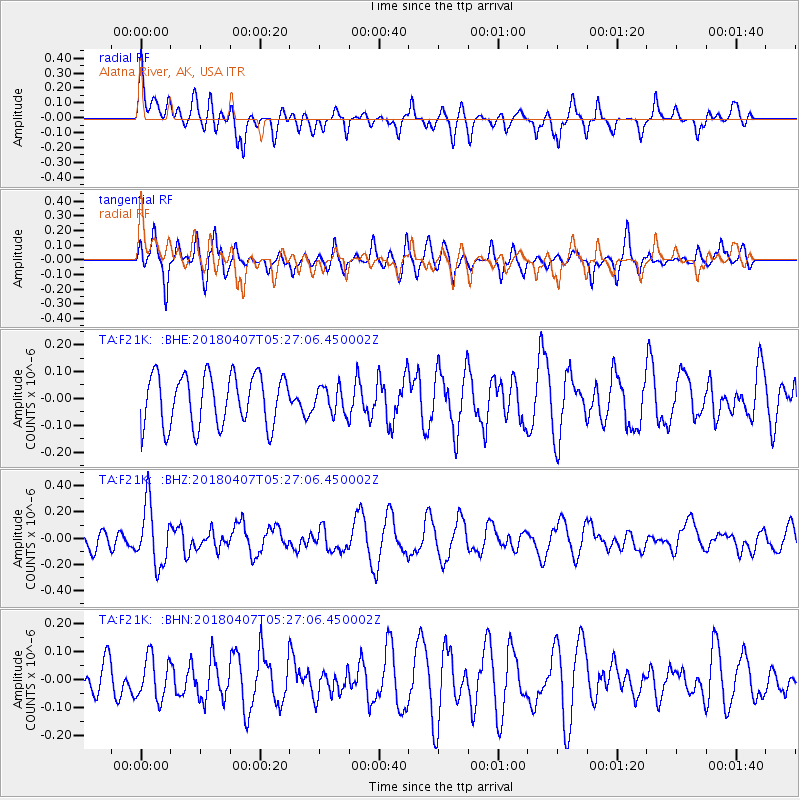
F21K Alatna River, AK, USA - Earthquake Result Viewer
*The percent match for this event was below the threshold and hence no stack was calculated.
| Earthquake location: |
New Britain Region, P.N.G. |
| Earthquake latitude/longitude: |
-5.5/152.0 |
| Earthquake time(UTC): |
2018/04/07 (097) 05:15:20 GMT |
| Earthquake Depth: |
35 km |
| Earthquake Magnitude: |
5.3 Mww |
| Earthquake Catalog/Contributor: |
NEIC PDE/us |
|
| Network: |
TA USArray Transportable Network (new EarthScope stations) |
| Station: |
F21K Alatna River, AK, USA |
| Lat/Lon: |
67.22 N/153.48 W |
| Elevation: |
597 m |
|
| Distance: |
82.1 deg |
| Az: |
18.673 deg |
| Baz: |
234.936 deg |
| Ray Param: |
$rayparam |
*The percent match for this event was below the threshold and hence was not used in the summary stack. |
|
| Radial Match: |
61.423546 % |
| Radial Bump: |
400 |
| Transverse Match: |
72.63511 % |
| Transverse Bump: |
400 |
| SOD ConfigId: |
13570011 |
| Insert Time: |
2019-04-30 02:23:16.695 +0000 |
| GWidth: |
2.5 |
| Max Bumps: |
400 |
| Tol: |
0.001 |
|
Signal To Noise
| Channel | StoN | STA | LTA |
| TA:F21K: :BHZ:20180407T05:27:06.450002Z | 3.0614827 | 2.2886199E-7 | 7.475528E-8 |
| TA:F21K: :BHN:20180407T05:27:06.450002Z | 1.2456142 | 7.512219E-8 | 6.030936E-8 |
| TA:F21K: :BHE:20180407T05:27:06.450002Z | 0.5195094 | 4.955671E-8 | 9.539137E-8 |
| Arrivals |
| Ps | |
| PpPs | |
| PsPs/PpSs | |


