You are here: Home > Network List > TA - USArray Transportable Network (new EarthScope stations) Stations List
> Station P15A Leamington, UT, USA > Earthquake Result Viewer
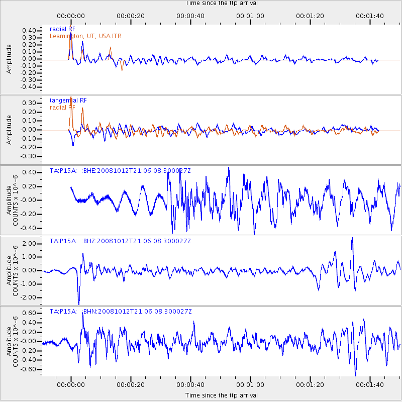
P15A Leamington, UT, USA - Earthquake Result Viewer
*The percent match for this event was below the threshold and hence no stack was calculated.
| Earthquake location: |
Southern Bolivia |
| Earthquake latitude/longitude: |
-20.1/-65.0 |
| Earthquake time(UTC): |
2008/10/12 (286) 20:55:41 GMT |
| Earthquake Depth: |
353 km |
| Earthquake Magnitude: |
6.0 MB, 6.2 MW, 6.2 MW |
| Earthquake Catalog/Contributor: |
WHDF/NEIC |
|
| Network: |
TA USArray Transportable Network (new EarthScope stations) |
| Station: |
P15A Leamington, UT, USA |
| Lat/Lon: |
39.57 N/112.28 W |
| Elevation: |
1576 m |
|
| Distance: |
74.0 deg |
| Az: |
323.773 deg |
| Baz: |
134.07 deg |
| Ray Param: |
$rayparam |
*The percent match for this event was below the threshold and hence was not used in the summary stack. |
|
| Radial Match: |
64.545 % |
| Radial Bump: |
341 |
| Transverse Match: |
50.711872 % |
| Transverse Bump: |
400 |
| SOD ConfigId: |
2560 |
| Insert Time: |
2010-03-06 10:28:28.257 +0000 |
| GWidth: |
2.5 |
| Max Bumps: |
400 |
| Tol: |
0.001 |
|
Signal To Noise
| Channel | StoN | STA | LTA |
| TA:P15A: :BHZ:20081012T21:06:08.300027Z | 14.2160845 | 8.5805664E-7 | 6.0358154E-8 |
| TA:P15A: :BHN:20081012T21:06:08.300027Z | 2.6373954 | 2.2659363E-7 | 8.591568E-8 |
| TA:P15A: :BHE:20081012T21:06:08.300027Z | 2.3881347 | 2.084494E-7 | 8.728545E-8 |
| Arrivals |
| Ps | |
| PpPs | |
| PsPs/PpSs | |


