You are here: Home > Network List > TA - USArray Transportable Network (new EarthScope stations) Stations List
> Station P15A Leamington, UT, USA > Earthquake Result Viewer
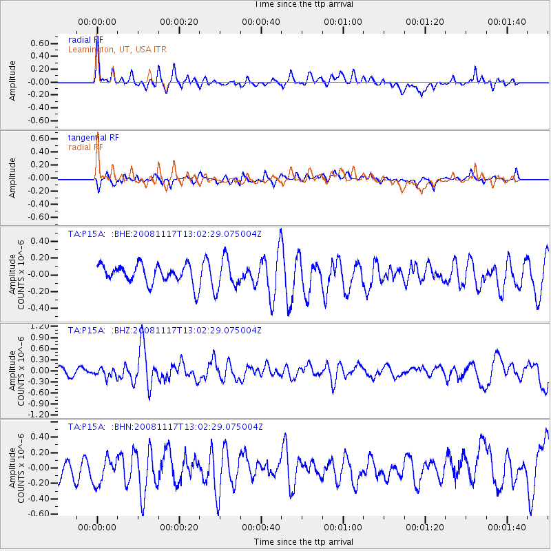
P15A Leamington, UT, USA - Earthquake Result Viewer
*The percent match for this event was below the threshold and hence no stack was calculated.
| Earthquake location: |
Arctic Ocean |
| Earthquake latitude/longitude: |
79.6/-116.1 |
| Earthquake time(UTC): |
2008/11/17 (322) 12:55:22 GMT |
| Earthquake Depth: |
7.0 km |
| Earthquake Magnitude: |
5.7 MW, 5.2 MS, 5.4 MB, 5.7 MW |
| Earthquake Catalog/Contributor: |
WHDF/NEIC |
|
| Network: |
TA USArray Transportable Network (new EarthScope stations) |
| Station: |
P15A Leamington, UT, USA |
| Lat/Lon: |
39.57 N/112.28 W |
| Elevation: |
1576 m |
|
| Distance: |
40.2 deg |
| Az: |
175.477 deg |
| Baz: |
358.943 deg |
| Ray Param: |
$rayparam |
*The percent match for this event was below the threshold and hence was not used in the summary stack. |
|
| Radial Match: |
72.2399 % |
| Radial Bump: |
400 |
| Transverse Match: |
36.39998 % |
| Transverse Bump: |
400 |
| SOD ConfigId: |
2658 |
| Insert Time: |
2010-03-06 10:28:39.057 +0000 |
| GWidth: |
2.5 |
| Max Bumps: |
400 |
| Tol: |
0.001 |
|
Signal To Noise
| Channel | StoN | STA | LTA |
| TA:P15A: :BHZ:20081117T13:02:29.075004Z | 1.1699547 | 1.2643966E-7 | 1.0807227E-7 |
| TA:P15A: :BHN:20081117T13:02:29.075004Z | 1.0800683 | 1.9300478E-7 | 1.7869682E-7 |
| TA:P15A: :BHE:20081117T13:02:29.075004Z | 1.5874867 | 1.7878403E-7 | 1.126208E-7 |
| Arrivals |
| Ps | |
| PpPs | |
| PsPs/PpSs | |


