You are here: Home > Network List > TA - USArray Transportable Network (new EarthScope stations) Stations List
> Station P15A Leamington, UT, USA > Earthquake Result Viewer
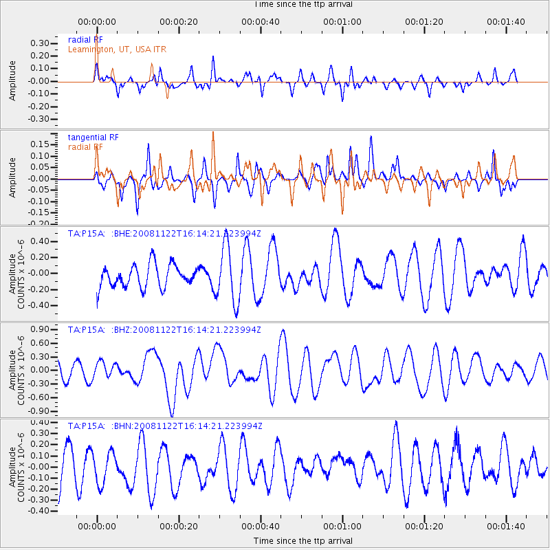
P15A Leamington, UT, USA - Earthquake Result Viewer
*The percent match for this event was below the threshold and hence no stack was calculated.
| Earthquake location: |
Southeast Of Loyalty Islands |
| Earthquake latitude/longitude: |
-22.5/171.2 |
| Earthquake time(UTC): |
2008/11/22 (327) 16:01:39 GMT |
| Earthquake Depth: |
57 km |
| Earthquake Magnitude: |
5.7 MB, 6.4 MW, 6.4 MW |
| Earthquake Catalog/Contributor: |
WHDF/NEIC |
|
| Network: |
TA USArray Transportable Network (new EarthScope stations) |
| Station: |
P15A Leamington, UT, USA |
| Lat/Lon: |
39.57 N/112.28 W |
| Elevation: |
1576 m |
|
| Distance: |
94.3 deg |
| Az: |
48.919 deg |
| Baz: |
244.384 deg |
| Ray Param: |
$rayparam |
*The percent match for this event was below the threshold and hence was not used in the summary stack. |
|
| Radial Match: |
42.16504 % |
| Radial Bump: |
281 |
| Transverse Match: |
28.227983 % |
| Transverse Bump: |
280 |
| SOD ConfigId: |
2658 |
| Insert Time: |
2010-03-06 10:28:42.498 +0000 |
| GWidth: |
2.5 |
| Max Bumps: |
400 |
| Tol: |
0.001 |
|
Signal To Noise
| Channel | StoN | STA | LTA |
| TA:P15A: :BHZ:20081122T16:14:21.223994Z | 1.1056082 | 1.7249326E-7 | 1.5601663E-7 |
| TA:P15A: :BHN:20081122T16:14:21.223994Z | 0.8337491 | 1.5492586E-7 | 1.8581832E-7 |
| TA:P15A: :BHE:20081122T16:14:21.223994Z | 2.6306581 | 3.631644E-7 | 1.3805077E-7 |
| Arrivals |
| Ps | |
| PpPs | |
| PsPs/PpSs | |


