You are here: Home > Network List > TA - USArray Transportable Network (new EarthScope stations) Stations List
> Station P15A Leamington, UT, USA > Earthquake Result Viewer
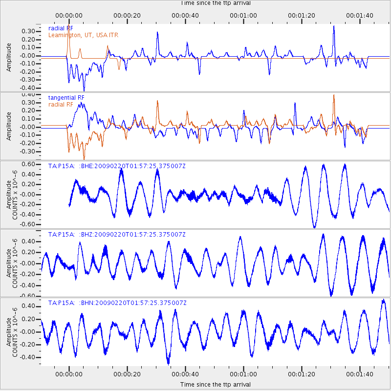
P15A Leamington, UT, USA - Earthquake Result Viewer
*The percent match for this event was below the threshold and hence no stack was calculated.
| Earthquake location: |
Fiji Islands Region |
| Earthquake latitude/longitude: |
-18.4/-178.7 |
| Earthquake time(UTC): |
2009/02/20 (051) 01:46:17 GMT |
| Earthquake Depth: |
515 km |
| Earthquake Magnitude: |
5.6 MW, 5.1 MB, 5.6 MW |
| Earthquake Catalog/Contributor: |
WHDF/NEIC |
|
| Network: |
TA USArray Transportable Network (new EarthScope stations) |
| Station: |
P15A Leamington, UT, USA |
| Lat/Lon: |
39.57 N/112.28 W |
| Elevation: |
1576 m |
|
| Distance: |
84.6 deg |
| Az: |
45.385 deg |
| Baz: |
241.002 deg |
| Ray Param: |
$rayparam |
*The percent match for this event was below the threshold and hence was not used in the summary stack. |
|
| Radial Match: |
41.217953 % |
| Radial Bump: |
400 |
| Transverse Match: |
57.98564 % |
| Transverse Bump: |
400 |
| SOD ConfigId: |
2658 |
| Insert Time: |
2010-03-06 10:28:44.937 +0000 |
| GWidth: |
2.5 |
| Max Bumps: |
400 |
| Tol: |
0.001 |
|
Signal To Noise
| Channel | StoN | STA | LTA |
| TA:P15A: :BHZ:20090220T01:57:25.375007Z | 0.7446604 | 1.8903125E-7 | 2.5384895E-7 |
| TA:P15A: :BHN:20090220T01:57:25.375007Z | 1.2013842 | 2.3599522E-7 | 1.9643609E-7 |
| TA:P15A: :BHE:20090220T01:57:25.375007Z | 1.2361836 | 2.575322E-7 | 2.0832846E-7 |
| Arrivals |
| Ps | |
| PpPs | |
| PsPs/PpSs | |


