You are here: Home > Network List > AK - Alaska Regional Network Stations List
> Station CHUM Lake Minchumina Broadband > Earthquake Result Viewer
CHUM Lake Minchumina Broadband - Earthquake Result Viewer
| Earthquake location: |
New Guinea, Papua New Guinea |
| Earthquake latitude/longitude: |
-5.8/142.5 |
| Earthquake time(UTC): |
2018/04/07 (097) 05:48:38 GMT |
| Earthquake Depth: |
10 km |
| Earthquake Magnitude: |
6.3 Mww |
| Earthquake Catalog/Contributor: |
NEIC PDE/us |
|
| Network: |
AK Alaska Regional Network |
| Station: |
CHUM Lake Minchumina Broadband |
| Lat/Lon: |
63.88 N/152.31 W |
| Elevation: |
58 m |
|
| Distance: |
84.6 deg |
| Az: |
23.801 deg |
| Baz: |
245.11 deg |
| Ray Param: |
0.045365192 |
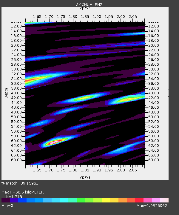
| Estimated Moho Depth: |
60.5 km |
| Estimated Crust Vp/Vs: |
1.72 |
| Assumed Crust Vp: |
6.566 km/s |
| Estimated Crust Vs: |
3.829 km/s |
| Estimated Crust Poisson's Ratio: |
0.24 |
|
| Radial Match: |
89.15961 % |
| Radial Bump: |
400 |
| Transverse Match: |
75.78838 % |
| Transverse Bump: |
400 |
| SOD ConfigId: |
13570011 |
| Insert Time: |
2019-04-30 02:25:29.881 +0000 |
| GWidth: |
2.5 |
| Max Bumps: |
400 |
| Tol: |
0.001 |
|

Signal To Noise
| Channel | StoN | STA | LTA |
| AK:CHUM: :BHZ:20180407T06:00:40.688003Z | 10.862837 | 1.7793092E-6 | 1.6379785E-7 |
| AK:CHUM: :BHN:20180407T06:00:40.688003Z | 3.1338034 | 6.8472497E-7 | 2.1849647E-7 |
| AK:CHUM: :BHE:20180407T06:00:40.688003Z | 3.4073157 | 5.354059E-7 | 1.5713422E-7 |
| Arrivals |
| Ps | 6.8 SECOND |
| PpPs | 24 SECOND |
| PsPs/PpSs | 31 SECOND |


