You are here: Home > Network List > AK - Alaska Regional Network Stations List
> Station DHY Denali Highway > Earthquake Result Viewer
DHY Denali Highway - Earthquake Result Viewer
| Earthquake location: |
New Guinea, Papua New Guinea |
| Earthquake latitude/longitude: |
-5.8/142.5 |
| Earthquake time(UTC): |
2018/04/07 (097) 05:48:38 GMT |
| Earthquake Depth: |
10 km |
| Earthquake Magnitude: |
6.3 Mww |
| Earthquake Catalog/Contributor: |
NEIC PDE/us |
|
| Network: |
AK Alaska Regional Network |
| Station: |
DHY Denali Highway |
| Lat/Lon: |
63.08 N/147.38 W |
| Elevation: |
1609 m |
|
| Distance: |
86.3 deg |
| Az: |
25.406 deg |
| Baz: |
249.65 deg |
| Ray Param: |
0.044123843 |
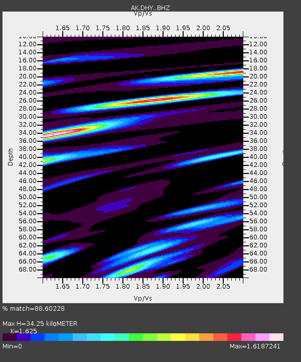
| Estimated Moho Depth: |
34.25 km |
| Estimated Crust Vp/Vs: |
1.62 |
| Assumed Crust Vp: |
6.566 km/s |
| Estimated Crust Vs: |
4.041 km/s |
| Estimated Crust Poisson's Ratio: |
0.20 |
|
| Radial Match: |
88.60228 % |
| Radial Bump: |
400 |
| Transverse Match: |
71.89965 % |
| Transverse Bump: |
400 |
| SOD ConfigId: |
13570011 |
| Insert Time: |
2019-04-30 02:25:34.831 +0000 |
| GWidth: |
2.5 |
| Max Bumps: |
400 |
| Tol: |
0.001 |
|

Signal To Noise
| Channel | StoN | STA | LTA |
| AK:DHY: :BHZ:20180407T06:00:49.287979Z | 7.831873 | 1.3645341E-6 | 1.7422833E-7 |
| AK:DHY: :BHN:20180407T06:00:49.287979Z | 2.2410321 | 5.9313084E-7 | 2.646686E-7 |
| AK:DHY: :BHE:20180407T06:00:49.287979Z | 2.9464164 | 5.921087E-7 | 2.0095894E-7 |
| Arrivals |
| Ps | 3.3 SECOND |
| PpPs | 13 SECOND |
| PsPs/PpSs | 17 SECOND |


