You are here: Home > Network List > TA - USArray Transportable Network (new EarthScope stations) Stations List
> Station P15A Leamington, UT, USA > Earthquake Result Viewer
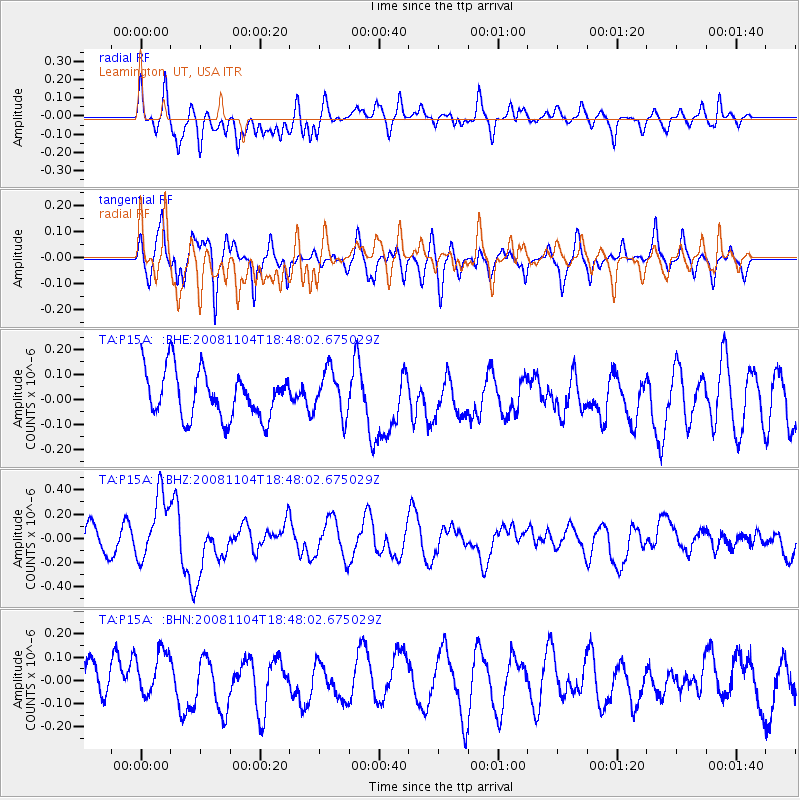
P15A Leamington, UT, USA - Earthquake Result Viewer
*The percent match for this event was below the threshold and hence no stack was calculated.
| Earthquake location: |
Vanuatu Islands |
| Earthquake latitude/longitude: |
-17.1/168.5 |
| Earthquake time(UTC): |
2008/11/04 (309) 18:35:45 GMT |
| Earthquake Depth: |
206 km |
| Earthquake Magnitude: |
5.7 MB, 6.3 MW, 6.3 MW |
| Earthquake Catalog/Contributor: |
WHDF/NEIC |
|
| Network: |
TA USArray Transportable Network (new EarthScope stations) |
| Station: |
P15A Leamington, UT, USA |
| Lat/Lon: |
39.57 N/112.28 W |
| Elevation: |
1576 m |
|
| Distance: |
92.8 deg |
| Az: |
49.489 deg |
| Baz: |
250.139 deg |
| Ray Param: |
$rayparam |
*The percent match for this event was below the threshold and hence was not used in the summary stack. |
|
| Radial Match: |
59.70932 % |
| Radial Bump: |
400 |
| Transverse Match: |
64.596214 % |
| Transverse Bump: |
400 |
| SOD ConfigId: |
2658 |
| Insert Time: |
2010-03-06 10:29:44.311 +0000 |
| GWidth: |
2.5 |
| Max Bumps: |
400 |
| Tol: |
0.001 |
|
Signal To Noise
| Channel | StoN | STA | LTA |
| TA:P15A: :BHZ:20081104T18:48:02.675029Z | 2.7558873 | 2.7130974E-7 | 9.844734E-8 |
| TA:P15A: :BHN:20081104T18:48:02.675029Z | 1.490065 | 1.10430285E-7 | 7.411105E-8 |
| TA:P15A: :BHE:20081104T18:48:02.675029Z | 0.95827454 | 8.995834E-8 | 9.387533E-8 |
| Arrivals |
| Ps | |
| PpPs | |
| PsPs/PpSs | |


