You are here: Home > Network List > TA - USArray Transportable Network (new EarthScope stations) Stations List
> Station B18K Kokolik River, AK, USA > Earthquake Result Viewer
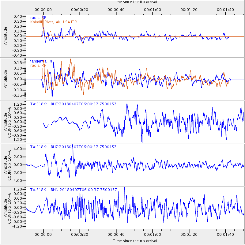
B18K Kokolik River, AK, USA - Earthquake Result Viewer
*The percent match for this event was below the threshold and hence no stack was calculated.
| Earthquake location: |
New Guinea, Papua New Guinea |
| Earthquake latitude/longitude: |
-5.8/142.5 |
| Earthquake time(UTC): |
2018/04/07 (097) 05:48:38 GMT |
| Earthquake Depth: |
10 km |
| Earthquake Magnitude: |
6.3 Mww |
| Earthquake Catalog/Contributor: |
NEIC PDE/us |
|
| Network: |
TA USArray Transportable Network (new EarthScope stations) |
| Station: |
B18K Kokolik River, AK, USA |
| Lat/Lon: |
69.36 N/161.80 W |
| Elevation: |
222 m |
|
| Distance: |
84.0 deg |
| Az: |
17.127 deg |
| Baz: |
235.735 deg |
| Ray Param: |
$rayparam |
*The percent match for this event was below the threshold and hence was not used in the summary stack. |
|
| Radial Match: |
73.416336 % |
| Radial Bump: |
400 |
| Transverse Match: |
73.24634 % |
| Transverse Bump: |
400 |
| SOD ConfigId: |
13570011 |
| Insert Time: |
2019-04-30 02:28:47.190 +0000 |
| GWidth: |
2.5 |
| Max Bumps: |
400 |
| Tol: |
0.001 |
|
Signal To Noise
| Channel | StoN | STA | LTA |
| TA:B18K: :BHZ:20180407T06:00:37.750015Z | 4.8337684 | 1.4126729E-6 | 2.9225083E-7 |
| TA:B18K: :BHN:20180407T06:00:37.750015Z | 2.2654076 | 3.4068395E-7 | 1.5038528E-7 |
| TA:B18K: :BHE:20180407T06:00:37.750015Z | 1.9920468 | 4.3850952E-7 | 2.2013013E-7 |
| Arrivals |
| Ps | |
| PpPs | |
| PsPs/PpSs | |


